New Mobile Site
We have just launched a new mobile version of this site - m.trainspots. This page will use your smart device's GPS to loctate you and guide you to locations that are close to your present location.
Location notes
In line with the GWML Electrification this bridge has been rebuilt (2012).
Lower Basildon is a small village next to Basildon Park.
What better way to spend an afternoon. Drop the family and kids off to enjoy the delights of the excellent National Trust and gardens whilst you, the railway observer or photographer takes a stroll down to this excellent vantage point.
As with a lot of Great Western vantage points this bridge is being rebuilt and the view will change. Updated images of both the shot and of the bridge itself would be welcomed to update the page.
Railway type and traffic
Passenger trains are mostly HSTs, 180s, 165s and Voyagers.
Of most interest will probably be the various freights winding their way from the London and Southampton areas to western and midland locations. These can be anything from Freightliner, Intermodal, Departmental. MOD, stone, Enterprise and car trains to name a few. However genuine stone trains only run this way if diverted off the Berks and Hants. As a rule of thumb, Tuesdays to Fridays are the busiest. Mid morning and mid to later afternoon being the best times.
Of most interest will probably be the various freights winding their way from the London and Southampton areas to western and midland locations. These can be anything from Freightliner, Intermodal, Departmental. MOD, stone, Enterprise and car trains to name a few. However genuine stone trains only run this way if diverted off the Berks and Hants. As a rule of thumb, Tuesdays to Fridays are the busiest. Mid morning and mid to later afternoon being the best times.
Environment
A quiet location on a wide bridge. The location is on a dead end public road to a church and farm. The bridge is surrounded by tall trees providing some shade.
The bridge can get quite busy, usually in school holidays, as the road is used as an exit from the nearby wildlife park.
The bridge can get quite busy, usually in school holidays, as the road is used as an exit from the nearby wildlife park.
Road directions
From the A359 between Pangbourne and Streatley, following the Thames Valley:
Once in village of Lower Basildon you will find a small lane heading north-west (Towards the Thames) signposted 'Church' and marked as a no through road. Follow for about 100 yards.
Click here to set up your location for directions to this location
Lower Basildon, Thames Valley map co-ordinates
Once in village of Lower Basildon you will find a small lane heading north-west (Towards the Thames) signposted 'Church' and marked as a no through road. Follow for about 100 yards.
Click here to set up your location for directions to this location
Lower Basildon, Thames Valley map co-ordinates
Parking
Parking is still possible on the bridge but it is narrower, since the 2012 rebuild. The church car-park at the bottom of the lane has also been reduced considerably.
Public transport
Amenities
There are several pubs in village, (as yet untried by the author).
Sun Compass
Sun Compass using Suncalc by brought to you by Vladimir Agafonkin:
It might be necessary to adjust the time to suit your visit, this link should open with the current day.
Lower Basildon, Thames Valley
Streetmap links
Lower Basildon, Thames Valley general view map
Lower Basildon, Thames Valley close up map
Windows Local Live Link - image quality may vary
Lower Basildon, Thames Valley
It might be necessary to adjust the time to suit your visit, this link should open with the current day.
Lower Basildon, Thames Valley
Googly map
Lower Basildon, Thames Valley general view map
Lower Basildon, Thames Valley close up map
Windows Local Live Link - image quality may vary
Lower Basildon, Thames Valley
Who likes this location on facebook
Railway Gen Group
Photographic notes
Good views in both directions. Longer lenses may help to increase variety of shots. Down line on south western side might be difficult to photograph if sun out. Most interesting trains use the two lines Thameside (north east side) though.
Trains from Reading could have the sun behind them during the earlier part of the day. The line runs north west to south east.
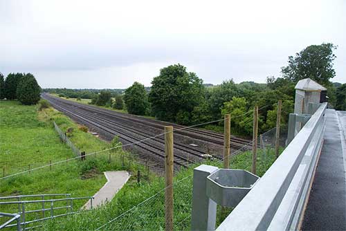
This bridge has recently been rebuilt and raised for the forthcoming GWML electrification. A telephoto is preferable to avoid shots being too high. The bridge parapets are now higher and most people will need a step ladder, or similar. The good news is that the brick buttress and trees on the west side looking towards Didcot have been removed and replaced by a crash barrier and fence giving a better view of trains coming from the Didcot direction.
Trains from Reading could have the sun behind them during the earlier part of the day. The line runs north west to south east.
This bridge has recently been rebuilt and raised for the forthcoming GWML electrification. A telephoto is preferable to avoid shots being too high. The bridge parapets are now higher and most people will need a step ladder, or similar. The good news is that the brick buttress and trees on the west side looking towards Didcot have been removed and replaced by a crash barrier and fence giving a better view of trains coming from the Didcot direction.
General views - All photographs © Chris Nevard unless otherwise stated
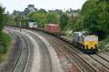
Fig 1 - Looking west - Image © Peter Lovell.
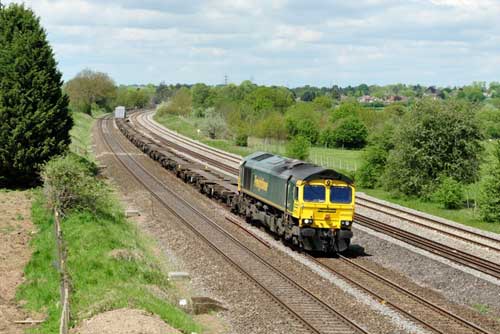
Fig 2 - Looking west - Image © Peter Lovell.
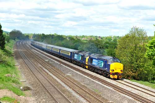
Fig 3 - Looking east - Image © Peter Lovell.
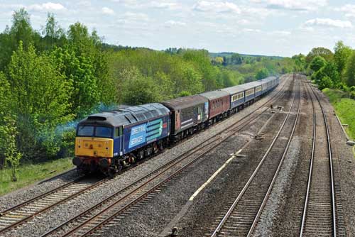
Fig 4 - Looking east
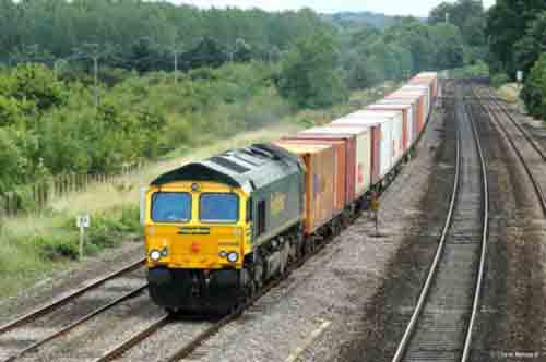
Fig 5 - Looking west
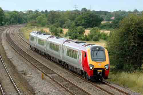
Fig 6 - Looking west Image © Olly Swan
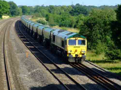
Fig 7 - Looking east Image © Olly Swan
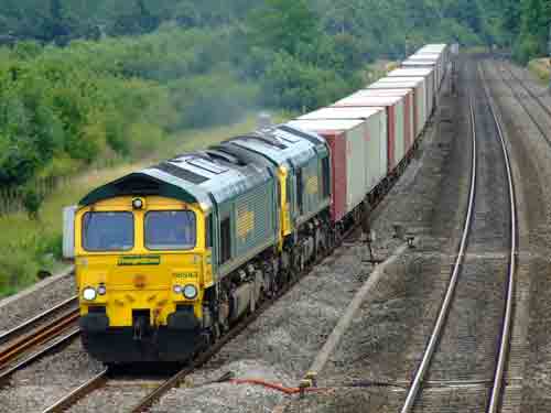
Fig 8 - Looking north - Image © Tony Rispoli
Bridge work developments as of 2013.
Disclaimer
All information contained within this is site is © Trainspots. The images used on this site remain the property of the original photographer, as credited at the top of the page, and are used with their kind permission.
The information on these pages is supplied for the benefit of railway enthusiasts who carry out a harmless hobby, and through the medium of photography and video, actually promote the railway industry. Railway enthusiasts can also act as eyes and ears against railway vandalism, and as such should surely be encouraged to do so by the supply of adequate information such as is found on this website.
This site has been created to assist railway photographers in their travels around the country. It is based on the personal knowledge and experience. No liability can be held against the web site or its contributions for incorrect information. Trainspots will endeavour to check all information and corrections will be accepted and posted accordingly.
Advice as to the locations general environment is given as a guide on each page. This information is a GUIDE only. ALWAYS be careful with your equipment, Trainspots can not be held responsible for your personal security. Avoid leaving your property on display for all to see, be aware of your surroundings at all times. There are, sadly, people who will not think twice about trying to steal your equipment.
Trainspots DOES NOT condone trespass and none of the information on this site should be taken as a right to trespass on either railway or private land. To the best of our knowledge all locations are publicly accessible areas, where they are not contact information will be given to the appropriate authority for permission to be obtained.
The content of this site is created and intended for all age ranges but the content of sites linked from this site are not subject to the same intentions. Trainspots will attempt to check links for validity but as time passes and the site grows this will not always be possible. Broken, or indeed updates to, links should be submitted to the editor for inclusion in the updates. All links external to the Trainspots site are opened in a new browser window. Trainspots has been running now for over 10 years and there are imitation sites and guides to railfotspots. But we are a free site and we continue on the path we started out on over a decade ago to provide a useful guide to UK Railway Photographic Locations.