New Mobile Site
We have just launched a new mobile version of this site - m.trainspots. This page will use your smart device's GPS to loctate you and guide you to locations that are close to your present location.
Location notes
Lancashire (or Technically just into Greater Manchester)
Irwell Vale is between Rawtenstall (the northern most point of the ELR) and Ramsbottom (the mid point on the ELR) trains take about 5 minutes to reach there from Rawtenstall (Southbound) or Ramsbottom (Northbound).
Irwell Vale is between Rawtenstall (the northern most point of the ELR) and Ramsbottom (the mid point on the ELR) trains take about 5 minutes to reach there from Rawtenstall (Southbound) or Ramsbottom (Northbound).
Railway type and traffic
The East Lancashire Railway is a Heritage line. Most traffic is confined to Saturday and Sunday although the line does operate a summer timetable which includes running on some weekdays. For timetable and special events details look at the ELR Website.
Environment
Irwell Vale is a picturesque village with a Station (or halt to be specific). The enhabitants are used to Railway enthusiasts with cameras and suchlike but should also be treated with respect - it’s a quiet village so no tearing through there at breakneck speed to catch a minus 2 connection!
Road directions
Route One
From Bury take the M66 Northbound (signposted Burnley/Blackburn). Carry on northbound for about 7 miles taking your second exit signposted Haslingden/Accrington – this is still a dual carriageway immediately take first exit again probably less that ¼ mile. You will come off at a roundabout with The Woolpack pub to your left, take first exit left (signposted Edenfield). Follow the road down for about ¾ of a mile (you will see the motorway you’ve just come off to your left) and at the bottom of the hill (*Sharp Bend*) turn right which is almost straight on in effect. (then see Local Route below).
If you end up in Rawtenstall by mistake follow Route Two
Route Two
From Rawtenstall station car park, exit next to the station building and turn right (onto Bury Road). Follow the road up for around 3 miles, on your way you will pass The Railway pub (right hand side), The Whitchaff Inn (right hand side) then into a 60mph Zone passing Horncliffe Mansion on your left. As you enter Edenfield the speed limit drops back to 40mph. At the traffic lights turn sharp right, almost back on yourself (Signposted Blackburn/Haslingden). Follow the road down for about a mile, at the bottom of the hill you will go over the railway and road flattens, after about 100 yards take a sharp left (not straight on left!!) then see Local Route below.
Local Route
Carry on for another ½ mile or so (If you’re on the right road you will see the Sewage treatment plant to your left). You will enter Irwell Vale over a small bridge, turn directly left, passing the phonebox and crossing the river. As you bear right the station is on your left hand side - the carpark entrance being right next to the crossing gates.
NB Irwell Vale is effectively a Cul-de-Sac if you are in a car. The only way out is the way you have come
Click here to set up your location for directions to this location
ELR, Irwell Vale Station map co-ordinates
Parking
Irwell Vale station has a small carpark (will take about 12 cars) - this is a very popular location in good weather so you might not always get on the carpark - additional parking is limited but I’ve never been there and not been able to park. It isn’t advised to take your car across the tracks as this is private residents parking only and you’ll soon see that there’s not much room anyway.
Public transport
Amenities
There is a tea room in the village open on Summer weekends but I’m not sure where it is (it may well be in the church which hosts the Irwell Vale Photographers’ slideshows). No other shops or amenities so take some supplies with you!
Sun Compass
Sun Compass using Suncalc by brought to you by Vladimir Agafonkin:
It might be necessary to adjust the time to suit your visit, this link should open with the current day.
ELR, Irwell Vale Station
Streetmap links
ELR, Irwell Vale Station general view map
ELR, Irwell Vale Station close up map
Windows Local Live Link - image quality may vary
ELR, Irwell Vale Station
It might be necessary to adjust the time to suit your visit, this link should open with the current day.
ELR, Irwell Vale Station
Googly map
ELR, Irwell Vale Station general view map
ELR, Irwell Vale Station close up map
Windows Local Live Link - image quality may vary
ELR, Irwell Vale Station
Who likes this location on facebook
Photographic notes
This is a great location for Photography and Videoing alike. The light can be good throughout the day but tends to be better in the early morning for Northbound (to Rawtenstall) trains and in the afternoon for Southbound (to Bury) trains – That said I’ve taken photos there at all times of day. As a rule morning photography is best from the opposite side from the platform (The ‘paddock’ being a good vantage point) and vice versa in the afternoon.
Trackside photographs of Southbound (To Bury) trains are good from the trackside at the South (Bury) end of the station. See Irwell Vale South location and remember - if you’re going to go trackside wear high visibility clothing, keep your wits about you and acknowledge the train.
Accessing trackside is technically trespass and therefore done at your own risk. Neither Trainspots or the author accept responsibility for your actions or the consequences of them.
Links to photographs at this location
The BR Diesel Web
Rail-net - ELR EE Event
Northern Railways - Irwell Vale
General views - All photographs © Andy Slater unless otherwise stated
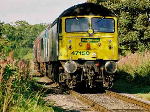
Fig 1 - Looking north

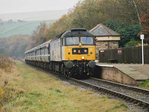
Fig 2 - Looking south

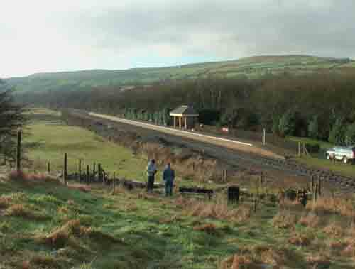
Fig 3 - Looking south Photo by Marcus Dawson

A similar angle to fig 2 but from further back up the hill. Here a more panoramic shot can be had. Trains can be seen arriving from the middle left of this picture.
Disclaimer
All information contained within this is site is © Trainspots. The images used on this site remain the property of the original photographer, as credited at the top of the page, and are used with their kind permission.
The information on these pages is supplied for the benefit of railway enthusiasts who carry out a harmless hobby, and through the medium of photography and video, actually promote the railway industry. Railway enthusiasts can also act as eyes and ears against railway vandalism, and as such should surely be encouraged to do so by the supply of adequate information such as is found on this website.
This site has been created to assist railway photographers in their travels around the country. It is based on the personal knowledge and experience. No liability can be held against the web site or its contributions for incorrect information. Trainspots will endeavour to check all information and corrections will be accepted and posted accordingly.
Advice as to the locations general environment is given as a guide on each page. This information is a GUIDE only. ALWAYS be careful with your equipment, Trainspots can not be held responsible for your personal security. Avoid leaving your property on display for all to see, be aware of your surroundings at all times. There are, sadly, people who will not think twice about trying to steal your equipment.
Trainspots DOES NOT condone trespass and none of the information on this site should be taken as a right to trespass on either railway or private land. To the best of our knowledge all locations are publicly accessible areas, where they are not contact information will be given to the appropriate authority for permission to be obtained.
The content of this site is created and intended for all age ranges but the content of sites linked from this site are not subject to the same intentions. Trainspots will attempt to check links for validity but as time passes and the site grows this will not always be possible. Broken, or indeed updates to, links should be submitted to the editor for inclusion in the updates. All links external to the Trainspots site are opened in a new browser window. Trainspots has been running now for over 10 years and there are imitation sites and guides to railfotspots. But we are a free site and we continue on the path we started out on over a decade ago to provide a useful guide to UK Railway Photographic Locations.


