New Mobile Site
We have just launched a new mobile version of this site - m.trainspots. This page will use your smart device's GPS to loctate you and guide you to locations that are close to your present location.
Location notes
Newburn Bridge is an ideal location all year round for the sun on the front of all southbound trains due to the curve.
Railway type and traffic
Passenger:
At the moment the passenger service is a mixture of Northern Rail Class 142, 156, 158, with Grand Central services using their HSTs.
Northern Rail operates an hourly service during Mon-Sat in both directions with services to/ from Middlesbrough- Necastle/ Hexham/ Carlisle. Times are at Hartlepool are northbound 02 past the hour, southbound 15 past the hour.
Test Trains:
They have been a recent up surge in Test Train usage on the Durham Coast Line through Hartlepool. Also Inspection Saloons can be seen operating. These include the NMT HST, Class 31, 57, 66 & 67 hauled trains.
Charter Trains:
Not that many charter services have used the Durham Coast Line, but when they do operate they can be hauled by a range of Classes including noted 31, 33, 37, 47, 56, 57, 60, 66 & 67.
Freight:
Freight services are currently operated by DRS, DB Schenker, FLHH, GBRf, with a range of traction from 20, 37, 47, 57, 60 & 66.
DRS operates flask traffic, 20, 37, 47, 57, 66.
DB Schenker operates Aluminium Ingot, Lime, Coal Hoppers. 60 & 66.
FLHH operates Cemnet traffic. 66.
GBRf operates Tyne Dock- Drax Coal. 66.
Other notes of the line:
The Durham Coast Line is a diversionary route for the ECML between Darlington- Durham- Newcastle.
Thus this is usually mainly freight when diversions are on. As the Tyne & Wear Metro extension to Sunderland put to a stop to regular diverted ECML passenger trains, due to a lack of paths between Pelaw- Sunderland.
When the signalling upgrade project is completed The Durham Coast Line through Hartlepool has been said will be "hammered" by freight, so could see DRS, DB Schenker, FLHH, GBRf and other operators services using the coastline, to free up paths on the ECML.
Environment
It is a relatively safe area and is visited by scores of enthusiasts. The car park is busy all day, with people coming to watch the sea and have their dinner.
This is an open location with no shelter nearby, unless you have a car. It is right next to the sea so open to the elements and sea spray when conditions are rough.
This is an open location with no shelter nearby, unless you have a car. It is right next to the sea so open to the elements and sea spray when conditions are rough.
Road directions
From the A1(M), Junction 60:
Head East on the A689 towards Sedgefield/ Hartlepool. Follow A689 into Hartlepool. Then follow directions mentioned in directions from A19.
From the A19 travelling from the south:
Take the A689 Eastbound and follow the A689 into Hartlepool towards the Town Centre. You will see Tesco Extra on your right side as you approach the town centre at the roundabout take a right hand turn heading east follow the road (Burn Road) down to the bottom then turn left then right onto the bridge.
From A19 travelling from the north:
Take the A179 Eastbound and follow the signs towards Hartlepool Marina/ Town Centre.
Following the signs for the Marina/ Town Centre will bring you to the Marina first, Asda will be on your right side. Follow the road over the bridge (over railway line) take a left (follow signs for train station) at the traffic lights. This left at the lights bring you onto Church Square about 50-100 yards there is a mini roundabout take it straight/ slightly left over now follow road signs for A178 Seaton Carew this road is now Church Street, at the bottom follow road towards the right at traffic lights. Then just follow the road (railway line is on your left) till you come to the bridge.
On the top of the bridge there is a left had turn this is the car park (only accessable from southbound carriageway).
Click here to set up your location for directions to this location
Hartlepool, Newburn Bridge map co-ordinates
Parking
There is ample parking overlooking the sea front on the bridge, access to carpark is from southbound carriage way.
Public transport
Rail:
Come out of the station turn left walk down Church Street follow the road round to the right at the traffic lights and follow the road (Mainsforth Terrace) along for about 1/4 mile till you reach the bridge.
Bus Services:
Stagecoach Hartlepool, runs service 12 past Newburn Bridge every 30 mins. Loads of services local and regional stop in the Town Centre 1/2 mile walk from Newburn Bridge, operated by Stagecoach Hartlepool, Stagecoach Transit, Arriva North East, Go- Ahead & Veolia Transport. National Express operates nationwide services.
Sail:
Hartlepool Marina is located about 1/2 mile away to the north of Newburn Bridge, follow directions for Historic Quay. For people wishing to visit by sea and somewhere to park their vessels.
Click here to set up your location for directions to this location
Amenities
Local essentials:
Tesco Extra, about 1/4 mile up Burn Road, at the junction of Burn Road/ A689 Belle Vue Way. McDonalds can be found opposite Tesco next to the roundabout.
Asda on the Marina, aprox 1/2 mile away, McDonalds can be found opposite Asda. Also within the area, can be found KFC, Burger King & Pizza Hut.
Morrisons same distance but next to Hartlepool United Football Club.
Middleton Grange Shopping Centre about 1/4 mile up Huckelhoven Way. Hartlepool Maritime Experience, 1/2 mile along Mainsforth Terrace, right over level crossing at the bottom of Church Street follow road along turn left and you will see it.
Chip Shops can be found about 1 mile away in Seaton Carew. On Navigation Point (numerous restauarnts can be found here as well) which is on the other side of the Marina about a mile away. There are numerous cafes, chippies and pubs that offer food in the Town Centre of Hartlepool and Seaton Carew.
Pie Shop:
When in Hartlepool you cant miss a visit to Morrell's Butchers on York Road (between Park Road and Lister Street), about 2 minutes walk from the Town Centre. Well reknowned for their pies.
Sun Compass
Sun Compass using Suncalc by brought to you by Vladimir Agafonkin:
It might be necessary to adjust the time to suit your visit, this link should open with the current day.
Hartlepool, Newburn Bridge
Streetmap links
Hartlepool, Newburn Bridge general view map
Hartlepool, Newburn Bridge close up map
Windows Local Live Link - image quality may vary
Hartlepool, Newburn Bridge
It might be necessary to adjust the time to suit your visit, this link should open with the current day.
Hartlepool, Newburn Bridge
Googly map
Hartlepool, Newburn Bridge general view map
Hartlepool, Newburn Bridge close up map
Windows Local Live Link - image quality may vary
Hartlepool, Newburn Bridge
Who likes this location on facebook
Railway Gen Group
Photographic notes
The line runs North to South.
You are able to tell by the signals when a train is due as the signals protect the level crossing and junction (cross over). With north bound trains having a 4 colour aspect signal. And south bound trains having semaphores controlled by Stranton Box.
You are able to tell by the signals when a train is due as the signals protect the level crossing and junction (cross over). With north bound trains having a 4 colour aspect signal. And south bound trains having semaphores controlled by Stranton Box.
General views - All photographs © Jonathan Hare unless otherwise stated
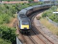
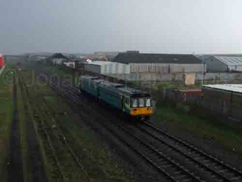
Fig 1 - Looking north
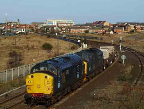
Fig 2 - Looking north
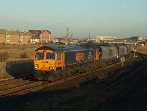
Fig 3 - Looking north
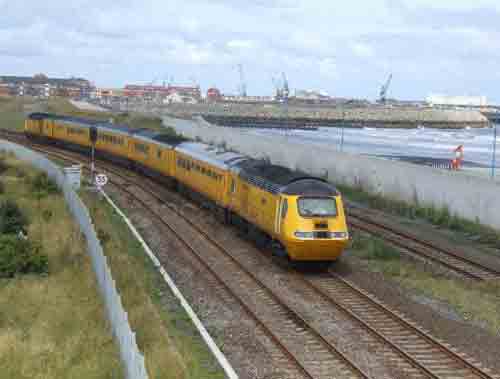
Fig 4 - Looking north
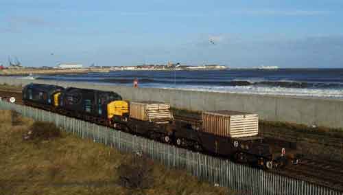
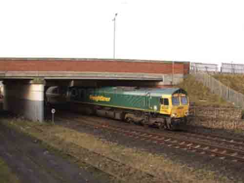
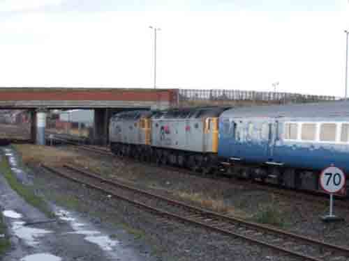
Fig 5 - Looking south
Taken from the south side of the bridge looking south onto the industrial estate that now occupies the former site of the steel works, with the steel works bridge clearly visable.
Fig 6 - Looking south
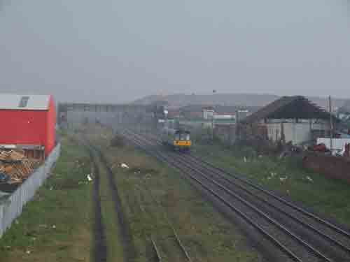
Fig 7 - Looking south
Taken from the bottom of the bridge looking south from the north (east) side to give a going away or approaching shot.
Fig 8 - Looking south
Disclaimer
All information contained within this is site is © Trainspots. The images used on this site remain the property of the original photographer, as credited at the top of the page, and are used with their kind permission.
The information on these pages is supplied for the benefit of railway enthusiasts who carry out a harmless hobby, and through the medium of photography and video, actually promote the railway industry. Railway enthusiasts can also act as eyes and ears against railway vandalism, and as such should surely be encouraged to do so by the supply of adequate information such as is found on this website.
This site has been created to assist railway photographers in their travels around the country. It is based on the personal knowledge and experience. No liability can be held against the web site or its contributions for incorrect information. Trainspots will endeavour to check all information and corrections will be accepted and posted accordingly.
Advice as to the locations general environment is given as a guide on each page. This information is a GUIDE only. ALWAYS be careful with your equipment, Trainspots can not be held responsible for your personal security. Avoid leaving your property on display for all to see, be aware of your surroundings at all times. There are, sadly, people who will not think twice about trying to steal your equipment.
Trainspots DOES NOT condone trespass and none of the information on this site should be taken as a right to trespass on either railway or private land. To the best of our knowledge all locations are publicly accessible areas, where they are not contact information will be given to the appropriate authority for permission to be obtained.
The content of this site is created and intended for all age ranges but the content of sites linked from this site are not subject to the same intentions. Trainspots will attempt to check links for validity but as time passes and the site grows this will not always be possible. Broken, or indeed updates to, links should be submitted to the editor for inclusion in the updates. All links external to the Trainspots site are opened in a new browser window. Trainspots has been running now for over 10 years and there are imitation sites and guides to railfotspots. But we are a free site and we continue on the path we started out on over a decade ago to provide a useful guide to UK Railway Photographic Locations.