New Mobile Site
We have just launched a new mobile version of this site - m.trainspots. This page will use your smart device's GPS to loctate you and guide you to locations that are close to your present location.
Location notes
A rural location on the GWML between Westbury and Frome in Somerset.
Railway type and traffic
The line is quite busy with FGW HSTs, DMUs on the Bristol to Frome and Weymouth route
All the Mendip stone traffic to and from both Whatley and Merehead passes here. Other freight includes the occasional Westbury to Moorswater cement working and ballast from Meldon Quarry to Westbury. Westbury is also a PW 'hub' and Berkley often sees engineers' trains heading to and from work sites in Somerset, Devon and Cornwall. The line also sees its share of excursion traffic including loco-hauled extras for the Glastonbury Festival in June. With luck, Bristol to Weymouth peak summer Saturday loco-hauled trains will continue in future years.
All the Mendip stone traffic to and from both Whatley and Merehead passes here. Other freight includes the occasional Westbury to Moorswater cement working and ballast from Meldon Quarry to Westbury. Westbury is also a PW 'hub' and Berkley often sees engineers' trains heading to and from work sites in Somerset, Devon and Cornwall. The line also sees its share of excursion traffic including loco-hauled extras for the Glastonbury Festival in June. With luck, Bristol to Weymouth peak summer Saturday loco-hauled trains will continue in future years.
Environment
There are two over bridges both carrying quiet country lanes over the line. The one to the east ('Pot Lane') sees the least road traffic but can be very muddy - the farmer herds his cattle over the bridge to reach the next field!
Beware on these lanes as certain local 'businessmen' use them for fly-tipping and it is possible to round a bend and find the lane completely blocked with debris.
Beware on these lanes as certain local 'businessmen' use them for fly-tipping and it is possible to round a bend and find the lane completely blocked with debris.
Road directions
The nearest major road is the A36. Just north of where it passes beneath the GWML there is a turning to the west. Follow this beneath the railway and past Frome Market. After about three quarters of a mile, take a turning to the right (Pot Lane) signed for Berkley Marsh. This quickly takes you to the easternmost of the two overbridges. The next turning to the right (Kemp's Lane, then Berlkey Lane) leads to the westernmost bridge.
Click here to set up your location for directions to this location
Berkley Marsh map co-ordinates
Click here to set up your location for directions to this location
Berkley Marsh map co-ordinates
Parking
There is limited roadside parking adjacent both bridges. Tuck your vehicle well into the side as large agricultural vehicles use these lanes. There is a bit of lay-by at Pot Lane bridge, but it is often muddy and often blocked by fly-tipping. However, if you can park there, you can watch the line from the comfort of your car!
Public transport
There really isn't any public transport within walking range of this location so the only option would be a taxi from Frome station.
Click here to set up your location for directions to this location
Click here to set up your location for directions to this location
Amenities
There is a pub called the 'Frome Flyer' on the A361 about a mile from the location 'as the crow flies' - its part of a small industrial estate visible from the westernmost bridge.
Accommodation
The 'Frome Flyer' adjoins a Premier Inn which offers good, predictable, quality accommodation. Otherwise stay in Frome itself, or in Bath, about 40 minutes' drive away.
Sun Compass
Sun Compass using Suncalc by brought to you by Vladimir Agafonkin:
It might be necessary to adjust the time to suit your visit, this link should open with the current day.
Berkley Marsh
Streetmap links
Berkley Marsh general view map
Berkley Marsh close up map
Windows Local Live Link - image quality may vary
Berkley Marsh
It might be necessary to adjust the time to suit your visit, this link should open with the current day.
Berkley Marsh
Googly map
Berkley Marsh general view map
Berkley Marsh close up map
Windows Local Live Link - image quality may vary
Berkley Marsh
Who likes this location on facebook
Railway Gen Group
Photographic notes
The line runs roughly north-east to south-west at Berkley. Both bridges offer (subject to vegetation growth) views in both directions from both sides of the line, so the location is usable pretty much through the day except mid-late afternoon when the sun aligns with the track. The Pot Lane bridge has the benefit of long views along the line to the east (which might be good for videos), plus a signal that helpfully indicates, by a flashing amber aspect, that the 'up' road is set towards Westbury at Fairwood Junction. Photos looking eastwards can be framed to include the famous Westbury White Horse and the chimney of Westbury Cement Works.
General views - All photographs © Glen Batten unless otherwise stated
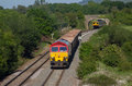
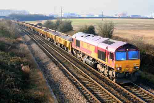
Fig 1 - Looking east
From the Pot Lane Bridge, north side
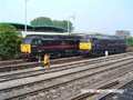
Fig 2 - Looking east
Regrettably, this shot from the south side of Pot Lane looking east has been completely obscured by a Network Rail communications mast installed in April 2009.
The only possibility is a very 'head-on' shot from the bridge itself, or in the complete absence of sun and shadows, from the north side using a longish lens.
Unfortunately, the neighbouring Berkley Lane bridge has no decent shot looking east in the morning either, due to trees that encroach on the line side.
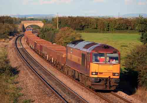
Fig 3 - Looking west
Pot Lane Bridge, south side.
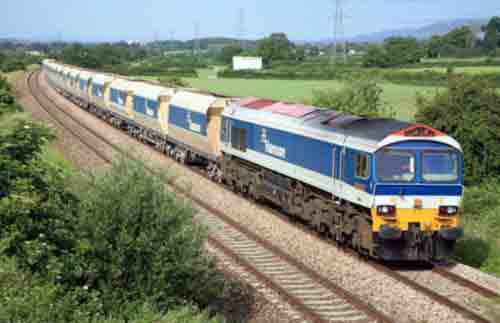
Fig 4 - Looking west
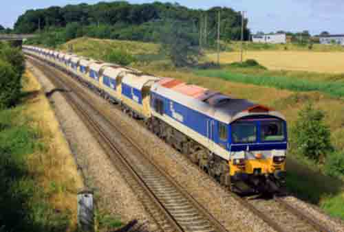
From the Berkley Lane Bridge, south side
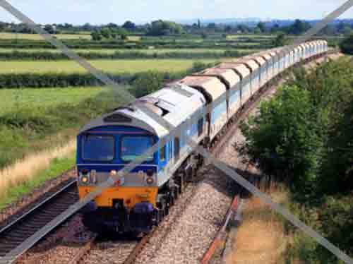
Fig 5 - Looking west
From Berkley Lane, north side
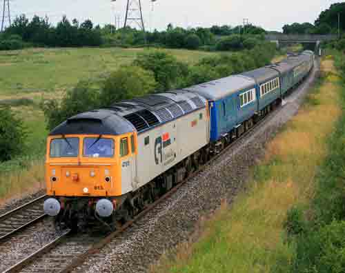
Fig 6 - Looking east
From Berkley Lane, north side
Disclaimer
All information contained within this is site is © Trainspots. The images used on this site remain the property of the original photographer, as credited at the top of the page, and are used with their kind permission.
The information on these pages is supplied for the benefit of railway enthusiasts who carry out a harmless hobby, and through the medium of photography and video, actually promote the railway industry. Railway enthusiasts can also act as eyes and ears against railway vandalism, and as such should surely be encouraged to do so by the supply of adequate information such as is found on this website.
This site has been created to assist railway photographers in their travels around the country. It is based on the personal knowledge and experience. No liability can be held against the web site or its contributions for incorrect information. Trainspots will endeavour to check all information and corrections will be accepted and posted accordingly.
Advice as to the locations general environment is given as a guide on each page. This information is a GUIDE only. ALWAYS be careful with your equipment, Trainspots can not be held responsible for your personal security. Avoid leaving your property on display for all to see, be aware of your surroundings at all times. There are, sadly, people who will not think twice about trying to steal your equipment.
Trainspots DOES NOT condone trespass and none of the information on this site should be taken as a right to trespass on either railway or private land. To the best of our knowledge all locations are publicly accessible areas, where they are not contact information will be given to the appropriate authority for permission to be obtained.
The content of this site is created and intended for all age ranges but the content of sites linked from this site are not subject to the same intentions. Trainspots will attempt to check links for validity but as time passes and the site grows this will not always be possible. Broken, or indeed updates to, links should be submitted to the editor for inclusion in the updates. All links external to the Trainspots site are opened in a new browser window. Trainspots has been running now for over 10 years and there are imitation sites and guides to railfotspots. But we are a free site and we continue on the path we started out on over a decade ago to provide a useful guide to UK Railway Photographic Locations.