New Mobile Site
We have just launched a new mobile version of this site - m.trainspots. This page will use your smart device's GPS to loctate you and guide you to locations that are close to your present location.
Location notes
Stoke Hammond is located on the West Coast Main Line, between the stations of Leighton Buzzard and Bletchley.
Note this location will become next to useless if new fencing is installed it hasn't to date.
Note this location will become next to useless if new fencing is installed it hasn't to date.
Railway type and traffic
Plenty of Virgin Anglo-Scottish to London and Midlands express passenger services. London Midland trains run the slower rural passenger services. There is also a wide mix of freight, by the likes of DB Schenker and Freightliner, and the odd DRS flask train.
Environment
Open fields in Bedfordshire. You will need to be able to walk 10 minutes in open country and fields to be able to access this site. One of the fields can get very boggy after rain, definitely not a location for Sunday best shoes!
Road directions
From Leighton Buzzard:
Take the A4146 sign posted Milton Keynes. This will take you through the village of Stoke Hammond itself. Take a left turn onto Newton Road, which is sign posted Newton Longville, and then the next right down Church Road. Following this small road round, you will come to a small green with the Church beyond. Park here.
Once parked, walk through the church yard to the back of it, where you will see a stile, crossing over this stile will bring you into a small farmyard, continue through this following the public footpath signs. Use the small bridge (nearly hidden in the hedge), to cross over into what looks like a garden don't worry you are still on a public footpath! Turn right in this 'garden', and follow the stiles until you come to a largish field. Turn left into the field, and follow the field around the perimeter. This will bring you parallel, and very close to the WCML. There are a number of locations to take photographs from, including above the line, across a small farm bridge, and my favorite, from just below the line.
The footpath is now fully open, and it is possible to access the site from both Stoke Hammond in the south, and Water Eaton in the north. The route of the path is not entirely obvious from the north heading south, so if visiting for the first time, it might be advisable to start from Stoke Hammond.
Click here to set up your location for directions to this location
Stoke Hammond map co-ordinates
Parking
The best place to park is near the green, making sure you allow access to the houses around the green, and enough room for other cars to pass. There is a lay-by on this road just down from the church entrance but the local farmer usually parks his large horse truck there.
If starting from the north end of the footpath, its possible to park you car just off the large roundabout off the A4146 on the new bit of dual carriageway which will become the Stoke Hammond/Linslade bypass, following the signs for Water Eaton, and finding some hard standing just off this roundabout.
If starting from the north end of the footpath, its possible to park you car just off the large roundabout off the A4146 on the new bit of dual carriageway which will become the Stoke Hammond/Linslade bypass, following the signs for Water Eaton, and finding some hard standing just off this roundabout.
Public transport
There is a limited bus service from Leighton Buzzard to Stoke Hammond (and onto Milton Keynes), provided by Red Kite (number 152). The current timetable, October 2003 onwards, lists 1 service on a Monday, and two services the rest of the week. Return services are little better. There is no Saturday or Sunday service.
Click here to set up your location for directions to this location
Click here to set up your location for directions to this location
Amenities
There are no amenities at the site it is a field. The village of Stoke Hammond has a post office and general store, and several pubs offering food during the day. Close by Leighton Buzzard (at Tesco, or on the high street) or Bletchley offer cash points from most if not all the local banks.
Accommodation
There is no accommodation in Stoke Hammond, but again there are several hotels and Bed and Breakfasts in Leighton Buzzard.
Sun Compass
Sun Compass using Suncalc by brought to you by Vladimir Agafonkin:
It might be necessary to adjust the time to suit your visit, this link should open with the current day.
Stoke Hammond
Streetmap links
Stoke Hammond general view map
Stoke Hammond close up map
Windows Local Live Link - image quality may vary
Stoke Hammond
It might be necessary to adjust the time to suit your visit, this link should open with the current day.
Stoke Hammond
Googly map
Stoke Hammond general view map
Stoke Hammond close up map
Windows Local Live Link - image quality may vary
Stoke Hammond
Who likes this location on facebook
Photographic notes
The WCML runs directly north to south through the location and as the normal WCML push-pull configuration is to have the loco at the north end of the formation to get head on shots you are working directly into the sun hence head on shots can only really be taken on cloudy days. This will also become less of a problem when the WCML goes over to Pendolino operation, and of course is not a problem with southbound freight. In addition, the usual WCML abundance of overhead line masts can be problematic, but there are enough points along the path to be able to site along them.
At some points along the path you are very close to the mainline, so a wide-ish angle lens is useful. I usually find that a 24-70 range of lens is usually fine. Also as it is a field location, you may also want to take a something to sit on for those quiet moments.
This area has been transformed by the construction of the Stoke Hammond and Linslade bypass, which passes directly behind the line at this point. Therefore there is a lot of construction work and associated noises, which will affect videographers.
Some work has been completed on the embankment at this site which, along with the opening of the footpath, has opened up two possible further shots. The first can be found by walking along the footpath in a northerly direction, and just past the trees, you see that the embankment has been cleared allowing southbound shots off the slow lines. By continuing northwards a northbound shot of the slow lines is also possible. This is only of use on a cloudy day, or very early morning in summer.
General views - All photographs © Richard Tearle unless otherwise stated
Fig 1 - Looking north
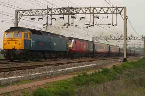
Fig 2 - Looking south
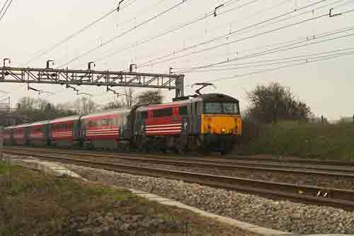
Fig 3 - Looking north
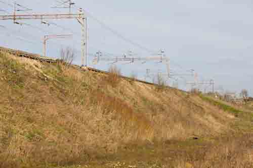
From the foot of the embankment, which is the east side of the line looking north. Views of the slow lines should be possible from here, but not the fast lines as they are to far over. This was taken on a bright March morning, with an 85mm lens.
Fig 4 - Looking south
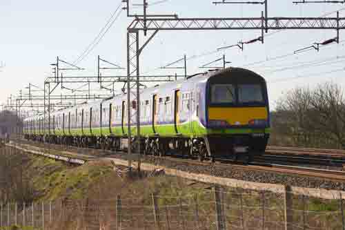
From the top of the embankment, by following the path northerly. Unfortunately only views of the slow lines are possible due to the OHLE in the way for the fast lines. This was taken on a bright March morning, with an 135mm lens.
Disclaimer
All information contained within this is site is © Trainspots. The images used on this site remain the property of the original photographer, as credited at the top of the page, and are used with their kind permission.
The information on these pages is supplied for the benefit of railway enthusiasts who carry out a harmless hobby, and through the medium of photography and video, actually promote the railway industry. Railway enthusiasts can also act as eyes and ears against railway vandalism, and as such should surely be encouraged to do so by the supply of adequate information such as is found on this website.
This site has been created to assist railway photographers in their travels around the country. It is based on the personal knowledge and experience. No liability can be held against the web site or its contributions for incorrect information. Trainspots will endeavour to check all information and corrections will be accepted and posted accordingly.
Advice as to the locations general environment is given as a guide on each page. This information is a GUIDE only. ALWAYS be careful with your equipment, Trainspots can not be held responsible for your personal security. Avoid leaving your property on display for all to see, be aware of your surroundings at all times. There are, sadly, people who will not think twice about trying to steal your equipment.
Trainspots DOES NOT condone trespass and none of the information on this site should be taken as a right to trespass on either railway or private land. To the best of our knowledge all locations are publicly accessible areas, where they are not contact information will be given to the appropriate authority for permission to be obtained.
The content of this site is created and intended for all age ranges but the content of sites linked from this site are not subject to the same intentions. Trainspots will attempt to check links for validity but as time passes and the site grows this will not always be possible. Broken, or indeed updates to, links should be submitted to the editor for inclusion in the updates. All links external to the Trainspots site are opened in a new browser window. Trainspots has been running now for over 10 years and there are imitation sites and guides to railfotspots. But we are a free site and we continue on the path we started out on over a decade ago to provide a useful guide to UK Railway Photographic Locations.