New Mobile Site
We have just launched a new mobile version of this site - m.trainspots. This page will use your smart device's GPS to loctate you and guide you to locations that are close to your present location.
Location notes
An unusual location, in that this is situated under three different lines. Serviced by the East Coast Main Line, Tyne and Wear metro, and local services to Sunderland and Hexham and beyond. The quayside is part of Newcastle Upon Tyne. Gateshead is just across the river.
Railway type and traffic
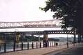
The River Tyne, and Newcastle, are famous for their bridges, and three of the seven bridges in the area carry rail traffic. The High Level Bridge is actually the oldest of the seven bridges over the Tyne, and carries the railway on the top, with the road underneath. In fact, it was the first bridge in the world to carry road and rail traffic. Although electrified, this bridge normally only carries local service DMUs.
The Metro Bridge, officially known as the Queen Elizabeth 2nd bridge, dates from 1981, and carries the Tyne and wear metro.
The King Edward Bridge carries the East Coast Main line, and is electrified for the purpose. It also carries freight, and local service DMUs, as well as Voyagers.
Incidentally, on the Gateshead side, the two Network rail Bridges have junctions going to the east and the west. This was designed to allow locomotives to access Gateshead TMD, from either bridge, but also means that trains from the east COULD cross the Tyne via the King Edward Bridge, and trains from the west COULD cross the Tyne via the high level bridge!
At the Gateshead end the metro enters the tunnels directly underneath the site of the former Gateshead TMD. That depot is now closed, and a housing scheme is being built upon it.
Environment
The quayside is a popular spot in Newcastle, and is a very popular nightspot. On some days, with the high buildings, it can get shaded, but it really is a semi sheltered location.
The area plays host to a popular Sunday market, and the area is safe at all times.
However, as this is Newcastle, do not wear a Sunderland FC jersey!
The area plays host to a popular Sunday market, and the area is safe at all times.
However, as this is Newcastle, do not wear a Sunderland FC jersey!
Road directions
Due to the nature of the location and the fact that meter parking is in force, it would be best not to drive to this location. See the public transport information instead.
Click here to set up your location for directions to this location
Newcastle Quayside map co-ordinates
Click here to set up your location for directions to this location
Newcastle Quayside map co-ordinates
Parking
Parking is very restricted, and instead, you should park your car outside the city centre, and use public transport.
Kingston Park, on the Tyne and Wear metro, and Heworth, offer park and ride facilities, as well as direct links to Newcastle city centre.
Kingston Park, on the Tyne and Wear metro, and Heworth, offer park and ride facilities, as well as direct links to Newcastle city centre.
Public transport
Newcastle Central National Rail station, and Central Station Metro are both about 10 minutes walk away from here. Take the Neville Street exit out of the metro station, walk right, and cross onto Collingwood Street, which follows onto Moseley Street. Turn right onto Dean Street, and carry on down the side, until you reach the quayside. Turn right, and carry on under the Tyne bridge, and you should see the aforementioned bridges ahead and above you.
If you are getting a bus, some services terminate at Central Station. However, Stagecoach routes 34 and 35 serve the quayside.
If your bus terminates at Gateshead, route 60 operates from the Interchange to Gateshead quays. Call traveline on 0870 608 2 608 for all bus times.
If you are coming from Wallsend or North Shields, get off the Metro at Manors station. From there, walk through the business park, and turn right onto Argyle Street. Then head down the hill to Sallyport Tower, and then take the steps. Continue down onto Sandgate, and take the steps on the right, which head onto the quayside. Turn right, and carry on towards, and under, the Tyne bridge. A free shuttle bus runs from Manors station.
Click here to set up your location for directions to this location
Amenities
There are a few pubs along the quayside. Central station is 10 minutes walk away, and if you cross the Millenium Bridge, there are toilets, and a cafe, in the Baltic Mills art Gallery.
Sun Compass
Sun Compass using Suncalc by brought to you by Vladimir Agafonkin:
It might be necessary to adjust the time to suit your visit, this link should open with the current day.
Newcastle Quayside
Streetmap links
Newcastle Quayside general view map
Newcastle Quayside close up map
Windows Local Live Link - image quality may vary
Newcastle Quayside
It might be necessary to adjust the time to suit your visit, this link should open with the current day.
Newcastle Quayside
Googly map
Newcastle Quayside general view map
Newcastle Quayside close up map
Windows Local Live Link - image quality may vary
Newcastle Quayside
Who likes this location on facebook
Railway Gen Group
Photographic notes
Bear in mind that as you are going to be pointing your camera sort of upwards, the sun may affect photos. Therefore, stand a bit further back from the bridges, and thus reduce the angle. Trains on the two Network Rail bridges will be moving slowly, those on the metro bridge will be doing 70 km/ph (about 45 m/ph).
The Quayside market takes place every Sunday, but this is only held on the eastern part of the quayside. In this instance, the market should not affect pictures.
Inevitably there will be noise on videos, as there are road bridges, which are very busy. Also, the roads on the Quayside do carry a fair bit of traffic.
General views - All photographs © Robert Clarke unless otherwise stated
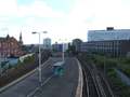
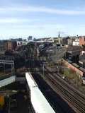
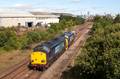
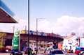
Fig 1 - Looking west
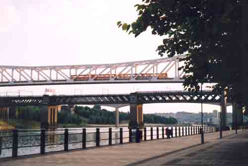
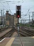
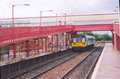
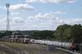
Fig 2 - Looking east
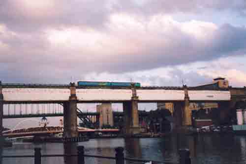
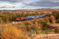
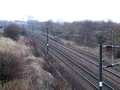
Fig 3 - Looking west
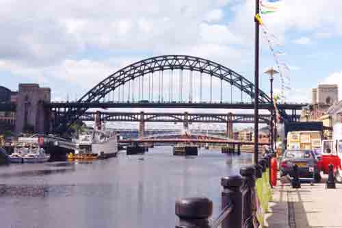
The bridges are, from top to bottom in terms of traffic/rail level, Tyne Bridge, King Edward Bridge, Metro Bridge, Swing Bridge.
Disclaimer
All information contained within this is site is © Trainspots. The images used on this site remain the property of the original photographer, as credited at the top of the page, and are used with their kind permission.
The information on these pages is supplied for the benefit of railway enthusiasts who carry out a harmless hobby, and through the medium of photography and video, actually promote the railway industry. Railway enthusiasts can also act as eyes and ears against railway vandalism, and as such should surely be encouraged to do so by the supply of adequate information such as is found on this website.
This site has been created to assist railway photographers in their travels around the country. It is based on the personal knowledge and experience. No liability can be held against the web site or its contributions for incorrect information. Trainspots will endeavour to check all information and corrections will be accepted and posted accordingly.
Advice as to the locations general environment is given as a guide on each page. This information is a GUIDE only. ALWAYS be careful with your equipment, Trainspots can not be held responsible for your personal security. Avoid leaving your property on display for all to see, be aware of your surroundings at all times. There are, sadly, people who will not think twice about trying to steal your equipment.
Trainspots DOES NOT condone trespass and none of the information on this site should be taken as a right to trespass on either railway or private land. To the best of our knowledge all locations are publicly accessible areas, where they are not contact information will be given to the appropriate authority for permission to be obtained.
The content of this site is created and intended for all age ranges but the content of sites linked from this site are not subject to the same intentions. Trainspots will attempt to check links for validity but as time passes and the site grows this will not always be possible. Broken, or indeed updates to, links should be submitted to the editor for inclusion in the updates. All links external to the Trainspots site are opened in a new browser window. Trainspots has been running now for over 10 years and there are imitation sites and guides to railfotspots. But we are a free site and we continue on the path we started out on over a decade ago to provide a useful guide to UK Railway Photographic Locations.