New Mobile Site
We have just launched a new mobile version of this site - m.trainspots. This page will use your smart device's GPS to loctate you and guide you to locations that are close to your present location.
Location notes
This junction no longer exists as a real junction it is now the divergence point for the lines to Derby and Nottingham from Chesterfield.
The old point work is completely removed and a new layout installed with 2 lines to both destinations and on the Northbound track from Derby there is a passing loop with very short cripple siding. However, this has been disconnected though the track remains.
The North Junction (to the North of the bridge) has also been removed this has now been relocated North of Bridge Street Tupton.The junction of the Erewash Valley Line and the Derby to Leeds Line, about 5 miles south of Chesterfield Station.
The location is the site of Clay Cross Station, now long gone.
Railway type and traffic
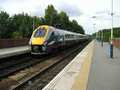
A wide variety, in todays terms, of traffic. Being a main line, Meridian Units, Cross Country Class 220/221, Cross Country 125 and Class 158 from East Midland Trains and Northern Spirit.
Freightliner and DB Schenker trains pass very regularly - a fair bit of departmental traffic as well.
Rarer traffic includes National rail Measurement Train, workings to and from Barrow Hill.
Freightliner and DB Schenker trains pass very regularly - a fair bit of departmental traffic as well.
Rarer traffic includes National rail Measurement Train, workings to and from Barrow Hill.
Environment
A residential area, with no reported problems with the locals. The bridge is on a school route and can be busy after 15:00 with the kids.
Road directions
From the M1, Junction 29:
Take the A6175 towards North Wingfield. Turn onto Station Road and then onto Ankerbold Road Park on Ankerbold road, which is off Station Road, which is itself off the A6175 in North Wingfield. The A6175 leads to Junc 29 of M1.
Click here to set up your location for directions to this location
Clay Cross South map co-ordinates
Parking
Parking is more difficult due to a variety of new businesses on Ankerbold Road which now use the road for customer and staff parking.
Public transport
The No. 97 stagecoach service from both Alfreton and Chesterfield serves the location directly. Both 51 and 54 stagecoach services stop close by. Alight at North Wingfield Church on 54 and walk down Station Road for about 10 mins. Alight at corner of Wingfield Road and Station New Road on service 51 about 5 mins.
Click here to set up your location for directions to this location
Click here to set up your location for directions to this location
Amenities
There is a recently refurbished small friendly local pub called 'The Shinnon' about 5 minutes up Station Road, this has a convenience store opposite, or a walk into Tupton centre will take 10 to 15 minuntes.
Accommodation
There is a small Bed and Breakfast on Church Lane in North Wingfield.
Sun Compass
Sun Compass using Suncalc by brought to you by Vladimir Agafonkin:
It might be necessary to adjust the time to suit your visit, this link should open with the current day.
Clay Cross South
Streetmap links
Clay Cross South general view map
Clay Cross South close up map
Windows Local Live Link - image quality may vary
Clay Cross South
It might be necessary to adjust the time to suit your visit, this link should open with the current day.
Clay Cross South
Googly map
Clay Cross South general view map
Clay Cross South close up map
Windows Local Live Link - image quality may vary
Clay Cross South
Who likes this location on facebook
Photographic notes
You can shoot in both directions, although facing south from 11am to 2pm may be a problem.
Looking south you can view the actual junction of the two lines, Clay Cross goods shed being on the left (now owned by the National Tramway Museum), plenty of foliage on both sides and the remains of the Clay Cross Pipe works in the distance - this view faces almost directly south.
Facing north is the ladder junction from the up and down main onto the up and down goods, the line curves slightly westwards after about 1/2 mile. there are trees on both sides of the line and the sides of the bridge are high - about 5 foot.
Note: There is another bridge about 1/2 to 3/4 mile north - on Bridge Street - that will yeild similar photos - the bridge sides are slightly lower and the location offers fine views toawrds Chesterfield, although northbound services can creep up unexpectedly!
General views - All photographs © Martin Barnsdall unless otherwise stated
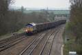
Fig 1 - Looking north - Image © Jason Rodhouse
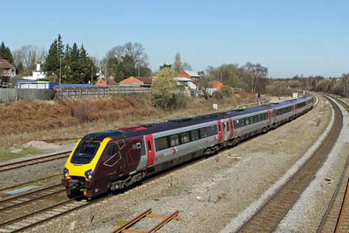
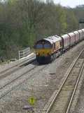
Fig 2 - Looking south - Image © Jason Rodhouse
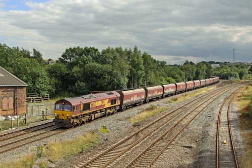
Fig 3 - Looking north - Image © Jason Rodhouse

Disclaimer
All information contained within this is site is © Trainspots. The images used on this site remain the property of the original photographer, as credited at the top of the page, and are used with their kind permission.
The information on these pages is supplied for the benefit of railway enthusiasts who carry out a harmless hobby, and through the medium of photography and video, actually promote the railway industry. Railway enthusiasts can also act as eyes and ears against railway vandalism, and as such should surely be encouraged to do so by the supply of adequate information such as is found on this website.
This site has been created to assist railway photographers in their travels around the country. It is based on the personal knowledge and experience. No liability can be held against the web site or its contributions for incorrect information. Trainspots will endeavour to check all information and corrections will be accepted and posted accordingly.
Advice as to the locations general environment is given as a guide on each page. This information is a GUIDE only. ALWAYS be careful with your equipment, Trainspots can not be held responsible for your personal security. Avoid leaving your property on display for all to see, be aware of your surroundings at all times. There are, sadly, people who will not think twice about trying to steal your equipment.
Trainspots DOES NOT condone trespass and none of the information on this site should be taken as a right to trespass on either railway or private land. To the best of our knowledge all locations are publicly accessible areas, where they are not contact information will be given to the appropriate authority for permission to be obtained.
The content of this site is created and intended for all age ranges but the content of sites linked from this site are not subject to the same intentions. Trainspots will attempt to check links for validity but as time passes and the site grows this will not always be possible. Broken, or indeed updates to, links should be submitted to the editor for inclusion in the updates. All links external to the Trainspots site are opened in a new browser window. Trainspots has been running now for over 10 years and there are imitation sites and guides to railfotspots. But we are a free site and we continue on the path we started out on over a decade ago to provide a useful guide to UK Railway Photographic Locations.