New Mobile Site
We have just launched a new mobile version of this site - m.trainspots. This page will use your smart device's GPS to loctate you and guide you to locations that are close to your present location.
Location notes
Summer 2011 - Due to vandalism in the area this bridge has been earmarked for a 'cage' enclosing the structure.
David Wood writes (25/03/08): It is correct that access to the bridge has been blocked from the Railway Triangle end but a friend mentioned to me that the Station Road entrance is still open, so I took a trip the long way round to check up and found out that this is indeed the case. There is a gate at the entrance, but its latch is missing, so it remains open. On the face of it, I suppose they only need to have one barrier to make the bridge unusable as part of a through route. This means that you can access the bridge but it is not accessible from the Hilsea direction. In fact, from the point of view of the photographer or videographer, the situation is improved by reason of there no longer being any noise or vibration caused by passing pedestrians.
A little used footbridge in the middle of an industrial estate just to the north of Portsmouth. On the east side of the triangle formed by the line from Portsmouth diverging to the west to Southampton / Eastleigh and to the east to Havant / Guildford / Brighton and the bit 'across the top'. The bridge only spans the Southampton line, but photographs of trains on the Portsmouth line can be obtained.
Railway type and traffic
SWT 444s on Portsmouth - Waterloo services (2 fasts and 1 slow each way an hour). SWT 450s on Basingstoke (or SWT 170s when from Reading) to Brighton (1 each way an hour). Southern 377s on Portsmouth - Brighton (1 each way an hour), Portsmouth - Victoria (1 each way an hour) and Victoria - Southampton (1 each way an hour) services and the very occasional Wessex Alphaline 158 on a Brighton - Bristol service.
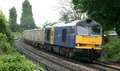
On the freight front there are 2 return workings a day: the Mendip Rail 59 hauled Merehead - Chichester - Westbury stone in bogie boxes and the DB Schenker 66 hauled Fawley - Holybourne - Eastleigh Yard bogie tanks.
On the freight front there are 2 return workings a day: the Mendip Rail 59 hauled Merehead - Chichester - Westbury stone in bogie boxes and the DB Schenker 66 hauled Fawley - Holybourne - Eastleigh Yard bogie tanks.
Environment
A footbridge in the centre of the aptly named 'Railway Triangle Industrial Estate'. It provides access from a road into the 'triangle' and is little used, except by workers of the estate. Consequently it is a built up area with lots of large industrial units. Not the nicest part of Portsmouth, so don't hang about after dark (not that there is anything to see after dark!), but its quite safe in the daytime with the estate security guards and lots of people in nearby warehouses etc. As for football colours, anything other than Pompey FC is not advisable when there is a match at Fratton Park!
Road directions
Coming along the M27 (from the west) or A27 (from the east) turn off at the junction with the A2030, and head north towards Drayton/Farlington. You will go up a steep hill over the railway line, as you come down the other side at the bottom of the hill turn left into Grove Road and then take the second turning on the left into Station Road. Follow the road round and you will see the footbridge on your left.
Click here to set up your location for directions to this location
Portsmouth, Farlington Junction map co-ordinates
Click here to set up your location for directions to this location
Portsmouth, Farlington Junction map co-ordinates
Parking
You can park right next to the footbridge, or just off the road nearby, but make sure its well out the way as the road gets very narrow here and there are lots of large lorries.
Public transport
Traveling by train, use the frequent SWT/Southern services to travel to Cosham or Hilsea station:
From Cosham:
(15/20 minute walk, pavements/roads)
Exit onto the south side of the line (opposite side to the station car park) and walk down the road, shortly turn left into Hawthorn Crescent which you should follow right the way round until you can see the pedestrian underpass under the motorway, turn left in front of the last block of flats and go behind the garages and cross the railway via the footbridge (which is not much good for fots!), then see below;
From Hilsea:
(20/30 minute walk; lots of mud)
Exit the station to the south side of the line (the side with the building) and turn left onto the 'Airport Service Road', cross over so you are on the pavement on the opposite side of the road to the railway line. Follow this past the industrial units, and keep on the pavement when it swings away to the right. Where the pavement runs out cross the road and head to go into the industrial unit on the left, just before you reach the gates turn left onto the (rather hidden) footpath and go up the steps onto Hilsea Lines, once on the top go down the steps on the other side. Turn left at the bottom of the steps and follow the path through the woods, when you reach the moat cross it via the bridge and then turn immediately left under the railway. Once under the line turn right and cross Port Creek via the footbridge which is parallel to the line, then go through the pedestrian underpass under the motorway. Turn right to go behind the garages after the first block of flats and cross the railway via the footbridge; then see below:
Once across the footbridge (you are now in the middle of the triangle) turn left and follow the track round until you join the road, walk along the road and go past the estate office, on your right you will see a car park between two industrial units, walk down the grass in between them and you will reach a path next to the railway (from where shots are possible). Follow this along until you reach the footbridge.
Click here to set up your location for directions to this location
Amenities
No facilities but there are chip shops/pizza houses/Chinese takeaways in Cosham High Street.
Accommodation
Plenty of hotels and Bed and Breakfasts in Portsmouth.
Sun Compass
Sun Compass using Suncalc by brought to you by Vladimir Agafonkin:
It might be necessary to adjust the time to suit your visit, this link should open with the current day.
Portsmouth, Farlington Junction
Streetmap links
Portsmouth, Farlington Junction general view map
Portsmouth, Farlington Junction close up map
Windows Local Live Link - image quality may vary
Portsmouth, Farlington Junction
It might be necessary to adjust the time to suit your visit, this link should open with the current day.
Portsmouth, Farlington Junction
Googly map
Portsmouth, Farlington Junction general view map
Portsmouth, Farlington Junction close up map
Windows Local Live Link - image quality may vary
Portsmouth, Farlington Junction
Who likes this location on facebook
Railway Gen Group
Photographic notes
This location is currently closed - as of March 2009 Railtrack have closed access to the bridge
As you stand on the bridge looking towards the junction and Havant the line on your left, which passes under the footbridge is the 'Southampton Line' and the line on your right is the 'Portsmouth Line' You get very little warning of approaching trains, so be on your toes! although if you watch the junction you can see when there are trains going onto/off the Southampton line.
The line is aligned east/west, but as you can not get to the south side of the lines (the footbridge only spans the Southampton line) this is really a cloudy day shot, although you can get reasonable results on a sunny day. If you go on a cloudy day then its up to your imagination what angles you choose; theres plenty of EMUs to practice on! Particularly if your going to do the south side shot of trains heading towards Southampton a zoom lens would be advisable to get over the large building in the middle of the junction (see pictures below), but could be useful anyway.
Video would not be much good as there is lots of loud background/traffic noise from the various industrial units.
General views - All photographs © Kevin Lee unless otherwise stated
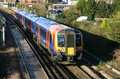
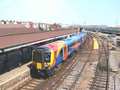
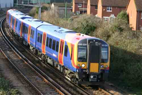
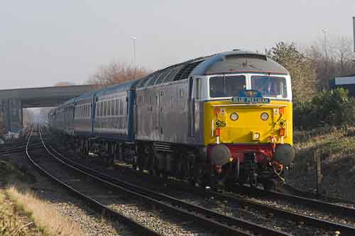
Fig 1 - Looking west
A train coming off the Portsmouth line.
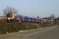
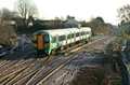
Fig 2 - Looking west
A train off the Portsmouth line.
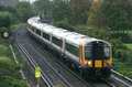
Fig 3 - Looking east
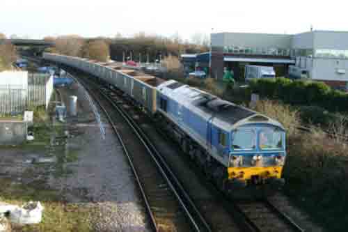
A train onto the Southampton Line, a north side 'cloudy shot'.
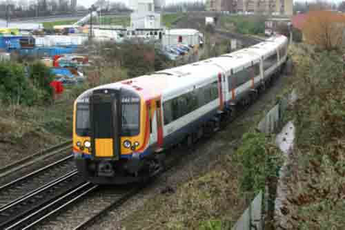
Fig 5 - Looking east
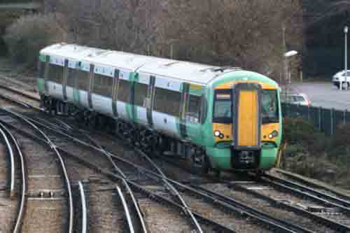
A train onto the Portsmouth line.
Fig 5 - Looking east
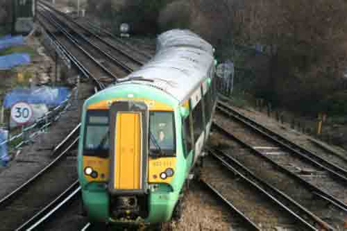
A train onto the Southampton Line, South Side Shot.
Fig 6 - Looking east - Photo © James Mayl
If you cross the footbridge, and walk about 25yads down the path it rises to above the level of the railway and you can shoot over a low fence.
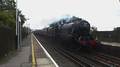
Fig 7 - Looking east
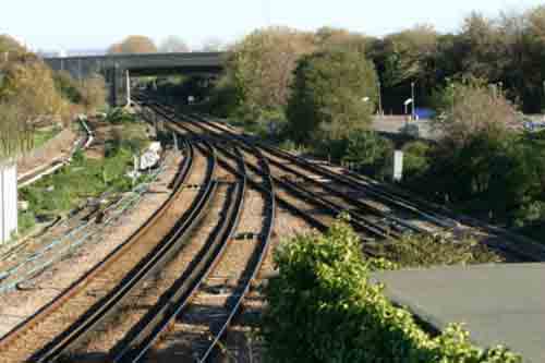
Fig 8 - Looking west
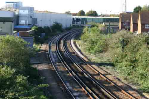
BEFORE they cut the trees down!
Disclaimer
All information contained within this is site is © Trainspots. The images used on this site remain the property of the original photographer, as credited at the top of the page, and are used with their kind permission.
The information on these pages is supplied for the benefit of railway enthusiasts who carry out a harmless hobby, and through the medium of photography and video, actually promote the railway industry. Railway enthusiasts can also act as eyes and ears against railway vandalism, and as such should surely be encouraged to do so by the supply of adequate information such as is found on this website.
This site has been created to assist railway photographers in their travels around the country. It is based on the personal knowledge and experience. No liability can be held against the web site or its contributions for incorrect information. Trainspots will endeavour to check all information and corrections will be accepted and posted accordingly.
Advice as to the locations general environment is given as a guide on each page. This information is a GUIDE only. ALWAYS be careful with your equipment, Trainspots can not be held responsible for your personal security. Avoid leaving your property on display for all to see, be aware of your surroundings at all times. There are, sadly, people who will not think twice about trying to steal your equipment.
Trainspots DOES NOT condone trespass and none of the information on this site should be taken as a right to trespass on either railway or private land. To the best of our knowledge all locations are publicly accessible areas, where they are not contact information will be given to the appropriate authority for permission to be obtained.
The content of this site is created and intended for all age ranges but the content of sites linked from this site are not subject to the same intentions. Trainspots will attempt to check links for validity but as time passes and the site grows this will not always be possible. Broken, or indeed updates to, links should be submitted to the editor for inclusion in the updates. All links external to the Trainspots site are opened in a new browser window. Trainspots has been running now for over 10 years and there are imitation sites and guides to railfotspots. But we are a free site and we continue on the path we started out on over a decade ago to provide a useful guide to UK Railway Photographic Locations.