New Mobile Site
We have just launched a new mobile version of this site - m.trainspots. This page will use your smart device's GPS to loctate you and guide you to locations that are close to your present location.
Location notes
A foot/farm level crossing near the small village of Stoke Bardolph, Nottinghamshire. It is about 4-5 miles east of Nottingham, on the Nottingham-Lincoln line. Crossing is user-worked gates.
Railway type and traffic
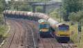
Passenger services are operated by a selection of East Midlands Trains units, which are mostly 156s and 158s, with most services running from Leicester to Lincoln. Also to be seen are 153s, and a 222 twice a day in each direction early morning/evening.
DB Schenker operate most of the freight, all DB diagrams are booked 66s apart from 6E41, which runs weekdays and passes at about 16:30-17:00. On Saturdays there are a few 60s that run as required. Traffic is mainly oil from Lindsey. Freightliner also operate a few trains during the week (66s). Occasional gypsum traffic is provided by GBRf 66s.
DB Schenker operate most of the freight, all DB diagrams are booked 66s apart from 6E41, which runs weekdays and passes at about 16:30-17:00. On Saturdays there are a few 60s that run as required. Traffic is mainly oil from Lindsey. Freightliner also operate a few trains during the week (66s). Occasional gypsum traffic is provided by GBRf 66s.
Environment
Rural setting, right on the edge of the urban area of Nottingham. The area is owned by Severn Trent Water and is used to grow crops. No farm animals nearby. Do not go after dark, as there is no street lighting. Not because you will get attacked, but because you ca not see anything! You can move back along the path by the edge of one of the fields which runs adjacent to the railway for variety. There is also a road bridge clearly visible on the new A612 bypass, accessible either via the road or a shortcut through vegetation (nettles included so be careful!)
There is a secondary school nearby, but other than that the only people you will see are the occasional dog walker, possibly farmers.
There is a secondary school nearby, but other than that the only people you will see are the occasional dog walker, possibly farmers.
Road directions
Location is on the A612 which runs from Nottingham to Southwell.
From the west/city area: head towards Nottingham city centre then follow signs for A612. You will eventually pass Victoria retail park. Continue towards Southwell. After the crossroads for Stoke Bardolph, you will cross over the line on the road bridge.
From the north: Follow the A614 towards the A6097. Take the A6097 to Lowdham. At the Lowdham roundabout, take a right towards Burton Joyce/Nottingham. Go through Burton Joyce up to where the road forks in to the A612 bypass and access road.
Click here to set up your location for directions to this location
Stoke Bardolph map co-ordinates
Parking
No car parks available, but park over on the access road where it forks off the A612 (near the traffic lights). Well lit and next to the main road so perfectly safe to leave your vehicle, though as with anywhere, do not leave valuables on display!
Cross the road and go over the fence and follow the path to the level crossing (about 400yds)
Cross the road and go over the fence and follow the path to the level crossing (about 400yds)
Public transport
Nottingham City Transport operate frequent bus services to the location under the Pathfinder brand (service 100). For those interested, service is provided by Optare Versas.
Ask the driver for New Plantation. If the driver does not know this (it is a fairly new bus stop) and you are travelling from Nottingham, say it is the first stop after Linden Grove (Carlton-le-Willows school). It is about 20 minutes from Nottingham, the buses continue to Southwell. Buses are every 20 mins Mon-Sat and every 60 mins Sunday.
Nearest station is Burton Joyce, though access is not easy and requires a 20-30 min walk to the location.
Click here to set up your location for directions to this location
Amenities
No shops in the area due to the location's rural setting. The Ferry Inn in Stoke Bardolph village is about 25 mins walk away.
Victoria Retail Park on the A162 has a Morrisons, Tesco Direct, Halfords, McDonalds and Lidl.
Victoria Retail Park on the A162 has a Morrisons, Tesco Direct, Halfords, McDonalds and Lidl.
Accommodation
Nottingham City Centre is best for accommodation.
Sun Compass
Sun Compass using Suncalc by brought to you by Vladimir Agafonkin:
It might be necessary to adjust the time to suit your visit, this link should open with the current day.
Stoke Bardolph
Streetmap links
Stoke Bardolph general view map
Stoke Bardolph close up map
Windows Local Live Link - image quality may vary
Stoke Bardolph
It might be necessary to adjust the time to suit your visit, this link should open with the current day.
Stoke Bardolph
Googly map
Stoke Bardolph general view map
Stoke Bardolph close up map
Windows Local Live Link - image quality may vary
Stoke Bardolph
Who likes this location on facebook
Photographic notes
The line runs east-west, so it is difficult to take photos facing east in the morning, and west in the evening, depending on the time of year.
On the north side of the crossing you can only take pictures facing east due to the vegetation. You can take photos both ways on the other side however. The path alongside the small cutting (with a small stream in it if it has been raining!) runs adjacent for about half a mile with scattered small trees, so not too difficult to take photos from.
The A612 bypass road bridge (only recently built!) is high sided but is good for taking photos from either side. Decent sized pavement on the west side, which conveniently is the better side for taking photos. Not recommended for videographers due to the constant background traffic, stick to the crossing.
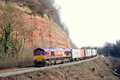
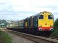
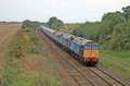
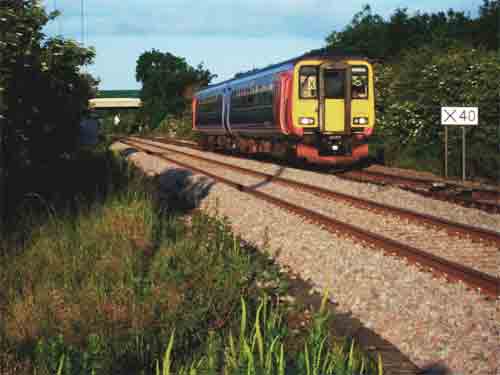
General views - All photographs © Miles Williams unless otherwise stated
Fig 1 - Looking south west
Disclaimer
All information contained within this is site is © Trainspots. The images used on this site remain the property of the original photographer, as credited at the top of the page, and are used with their kind permission.
The information on these pages is supplied for the benefit of railway enthusiasts who carry out a harmless hobby, and through the medium of photography and video, actually promote the railway industry. Railway enthusiasts can also act as eyes and ears against railway vandalism, and as such should surely be encouraged to do so by the supply of adequate information such as is found on this website.
This site has been created to assist railway photographers in their travels around the country. It is based on the personal knowledge and experience. No liability can be held against the web site or its contributions for incorrect information. Trainspots will endeavour to check all information and corrections will be accepted and posted accordingly.
Advice as to the locations general environment is given as a guide on each page. This information is a GUIDE only. ALWAYS be careful with your equipment, Trainspots can not be held responsible for your personal security. Avoid leaving your property on display for all to see, be aware of your surroundings at all times. There are, sadly, people who will not think twice about trying to steal your equipment.
Trainspots DOES NOT condone trespass and none of the information on this site should be taken as a right to trespass on either railway or private land. To the best of our knowledge all locations are publicly accessible areas, where they are not contact information will be given to the appropriate authority for permission to be obtained.
The content of this site is created and intended for all age ranges but the content of sites linked from this site are not subject to the same intentions. Trainspots will attempt to check links for validity but as time passes and the site grows this will not always be possible. Broken, or indeed updates to, links should be submitted to the editor for inclusion in the updates. All links external to the Trainspots site are opened in a new browser window. Trainspots has been running now for over 10 years and there are imitation sites and guides to railfotspots. But we are a free site and we continue on the path we started out on over a decade ago to provide a useful guide to UK Railway Photographic Locations.