New Mobile Site
We have just launched a new mobile version of this site - m.trainspots. This page will use your smart device's GPS to loctate you and guide you to locations that are close to your present location.
Location notes
As of October 2014 this foot crossing has been replaced with a footbridge. So naturally the views will change from the ones described.
This Derbyshire line side location is situated on the Midland Mainline between Derby and Sheet Stores Junction. It is about one mile north of Long Eaton station. A great feature of this particular location is you can always tell when something is approaching. It is not too far from a road level crossing so watching the signal will let you know when something is approaching travelling in the Derby direction, as the signal only goes off when the crossing's barriers are down. It only works for the other direction if a route is also set in the direction of the signal. Best thing to do when you want to know when a train is approaching in the Long Eaton direction is watch the crossing to see when cars are stopping. The drivers should also sound their horn just before the trains actually come into view.
This Derbyshire line side location is situated on the Midland Mainline between Derby and Sheet Stores Junction. It is about one mile north of Long Eaton station. A great feature of this particular location is you can always tell when something is approaching. It is not too far from a road level crossing so watching the signal will let you know when something is approaching travelling in the Derby direction, as the signal only goes off when the crossing's barriers are down. It only works for the other direction if a route is also set in the direction of the signal. Best thing to do when you want to know when a train is approaching in the Long Eaton direction is watch the crossing to see when cars are stopping. The drivers should also sound their horn just before the trains actually come into view.
Railway type and traffic
There are no shortage of passenger trains, mainly Central Trains Nottingham - Birmingham/Cardiff and MML London - Derby/Sheffield (plus ECS moves to and from Nottingham), so you\'re looking at HSTs, Meridians, 170s, 158s, 156s, 153s and the odd 150. When the Derby - Birmingham line is closed, Virgin divert their Voyagers this way too.
The line also gets its fair share of charters, both diesel and steam.
Unfortunately you will not see much freight on this line as it all goes via the Stenson freight line which is not too far away. This is however the diversionary route so if you know when it is going to happen, you will see DB Schenker (60/66/67) and Freightliner (66).
Link to Real Time Trains
RTT Link Sawley Road foot bridge
This link should be close to the location, but may not be the actual location so please check the page. This link will take you to what is happening 'around now'. Dates and times can be changed at the top of the page.
This link should be close to the location, but may not be the actual location so please check the page. This link will take you to what is happening 'around now'. Dates and times can be changed at the top of the page.
Environment
The location is in a large field containing a few horses, which usually stay well away from this particular corner. It is on a rarely used public footpath between Sawley and Breaston, where not one person passed me by in the two hours that I was there. Do not expect any peace and quiet though, as you are right next to an overhead M1 bridge.
Road directions
If you are local to the area, Sawley Road is the road that links up Sawley with Breaston, and the location is on the footpath that is clearly signposted at each end of the road. If you are not local, you will need to get to Long Eaton, which is not far from junction 25 of the M1 or the A52 between Derby and Nottingham. The town is clearly signposted from both roads. From there, get to Long Eaton station, which is slightly out of town but signposted well enough. Carry on under the railway bridge towards Sawley. You will pass two speed cameras, and immediately right is Draycott Road. Turn down this road and carry on straight along it, you will easily be able to see the M1 bridge. You can either park here just before the bridge, then get out and walk under the bridge and onto the footpath which is opposite the water works, or continue to Breaston, park there and walk along the footpath from the other end. Either way, you will easily be able to find the location when you walk along the footpath, just look out for where the railway goes under the M1.
Click here to set up your location for directions to this location
Sawley Road foot bridge map co-ordinates
Click here to set up your location for directions to this location
Sawley Road foot bridge map co-ordinates
Parking
As I mentioned above you can either park in Sawley or Breaston. Sawley is closer (less than 10 mins), but you will be leaving you car on a main road. I parked there for 2 hours with no problems.
If you would rather park on a quieter road, carry on along Sawley Road, over the level crossing and towards Breaston. There is a quiet residential cul-de-sac opposite the primary school. Again, the footpath is easily accessible and signposted from each end. At Sawley it begins opposite the water works entrance and at Breaston is begins next to the school. You could also park at the side of the road near the level crossing if you wanted to but I would not recommend it as there are not any designated public parking spaces.
If you would rather park on a quieter road, carry on along Sawley Road, over the level crossing and towards Breaston. There is a quiet residential cul-de-sac opposite the primary school. Again, the footpath is easily accessible and signposted from each end. At Sawley it begins opposite the water works entrance and at Breaston is begins next to the school. You could also park at the side of the road near the level crossing if you wanted to but I would not recommend it as there are not any designated public parking spaces.
Public transport
The nearest station is Long Eaton, and from there you can catch the regular 15 bus to Sawley. When you get onto Draycott Road you will see the M1 bridge at the end, so get off and walk to there. That particular area is known locally as Old Sawley so ask the driver for there. Do not worry if you go too far, the terminus is on Beresford Road and you will be able to get back onto Draycott Road and to the M1 bridge in less than 5 minutes.
Click here to set up your location for directions to this location
Click here to set up your location for directions to this location
Amenities
Unfortunately there is nothing nearby. If you fancy a walk into Sawley or Breaston, both have Co-ops. If eating in Breaston I would highly recommend the Bull's Head. I am not sure about Sawley.
Accommodation
I do not think there is anything nearby unless some of the pubs have rooms. There is a Novotel hotel near M1 J25 in Long Eaton but this is not in walking distance nor is it served by public transport.
Sun Compass
Sun Compass using Suncalc by brought to you by Vladimir Agafonkin:
It might be necessary to adjust the time to suit your visit, this link should open with the current day.
Sawley Road foot bridge
Streetmap links
Sawley Road foot bridge general view map
Sawley Road foot bridge close up map
Windows Local Live Link - image quality may vary
Sawley Road foot bridge
It might be necessary to adjust the time to suit your visit, this link should open with the current day.
Sawley Road foot bridge
Googly map
Sawley Road foot bridge general view map
Sawley Road foot bridge close up map
Windows Local Live Link - image quality may vary
Sawley Road foot bridge
Who likes this location on facebook
Photographic notes
As of October 2014 this foot crossing has been replaced with a footbridge. So naturally the views will change from the ones described.
As the area is open, there is no particular time when the sun is at its best. Trains can be photographed travelling in both directions, but please be aware that if you are looking for the best shots of trains travelling towards Derby, you are going to have to venture away from the public footpath and further up into the field.
As the area is open, there is no particular time when the sun is at its best. Trains can be photographed travelling in both directions, but please be aware that if you are looking for the best shots of trains travelling towards Derby, you are going to have to venture away from the public footpath and further up into the field.
General views - All photographs © James Farrell unless otherwise stated
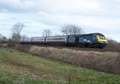
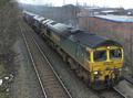
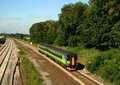
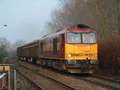
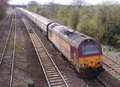
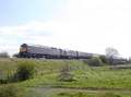
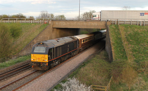
Fig 1 - Looking north west
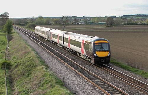
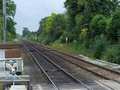
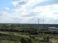
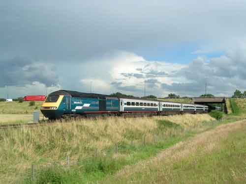
Fig 2 - Looking north east
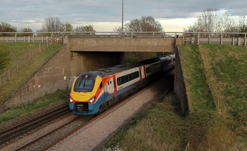
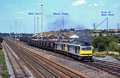
Fig 3 - Looking north east
This view will now include the footbridge in the shot.
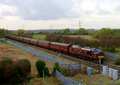
Fig 4 - Looking north west
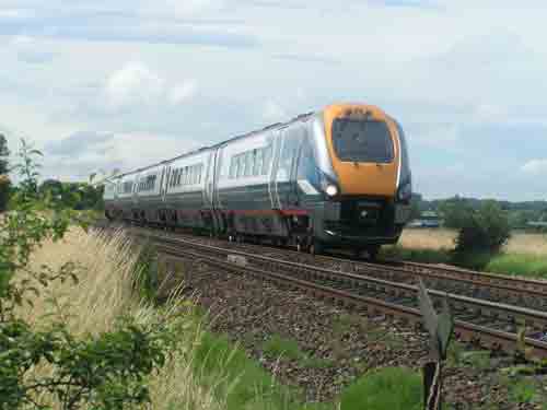
Fig 5 - Looking north west
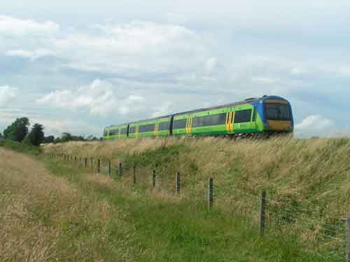
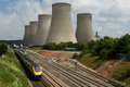
Fig 6 - Looking north east
Road noise from the M1 motorway will be quite apparent here.
Disclaimer
All information contained within this is site is © Trainspots. The images used on this site remain the property of the original photographer, as credited at the top of the page, and are used with their kind permission.
The information on these pages is supplied for the benefit of railway enthusiasts who carry out a harmless hobby, and through the medium of photography and video, actually promote the railway industry. Railway enthusiasts can also act as eyes and ears against railway vandalism, and as such should surely be encouraged to do so by the supply of adequate information such as is found on this website.
This site has been created to assist railway photographers in their travels around the country. It is based on the personal knowledge and experience. No liability can be held against the web site or its contributions for incorrect information. Trainspots will endeavour to check all information and corrections will be accepted and posted accordingly.
Advice as to the locations general environment is given as a guide on each page. This information is a GUIDE only. ALWAYS be careful with your equipment, Trainspots can not be held responsible for your personal security. Avoid leaving your property on display for all to see, be aware of your surroundings at all times. There are, sadly, people who will not think twice about trying to steal your equipment.
Trainspots DOES NOT condone trespass and none of the information on this site should be taken as a right to trespass on either railway or private land. To the best of our knowledge all locations are publicly accessible areas, where they are not contact information will be given to the appropriate authority for permission to be obtained.
The content of this site is created and intended for all age ranges but the content of sites linked from this site are not subject to the same intentions. Trainspots will attempt to check links for validity but as time passes and the site grows this will not always be possible. Broken, or indeed updates to, links should be submitted to the editor for inclusion in the updates. All links external to the Trainspots site are opened in a new browser window. Trainspots has been running now for over 10 years and there are imitation sites and guides to railfotspots. But we are a free site and we continue on the path we started out on over a decade ago to provide a useful guide to UK Railway Photographic Locations.