New Mobile Site
We have just launched a new mobile version of this site - m.trainspots. This page will use your smart device's GPS to loctate you and guide you to locations that are close to your present location.
Location notes
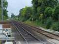
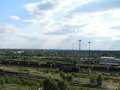
This location is on the Stenson to Sheet Stores line, about a mile south west of sheet stores. It is about half way between Nottingham and Derby.
Railway type and traffic
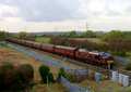
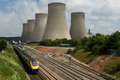
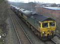
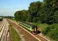
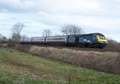
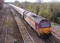
Traffic along here is mainly DB Schenker and Freightliner. There is a class 60 around 06:45. There are also Railtours and ECS along this route avoiding Derby.
Link to Real Time Trains
RTT Link Sawley, Harrington Bridge
This link should be close to the location, but may not be the actual location so please check the page. This link will take you to what is happening 'around now'. Dates and times can be changed at the top of the page.
This link should be close to the location, but may not be the actual location so please check the page. This link will take you to what is happening 'around now'. Dates and times can be changed at the top of the page.
Environment
The location is on a public footpath in open fields on top of a flood bank. Safety has not been a issue as far as I know, but if it is flooded it is probably best not to venture out into the fields. There are houses in one direction, and a church and a few pubs in the other.
Road directions
From the M1, Junction 24/24a:
Head west along the A50 to the first junction and then head north on the B6540. Go back under the M1 and then over 2 river bridges. The footpath is on the right just before the houses.
Click here to set up your location for directions to this location
Sawley, Harrington Bridge map co-ordinates
Head west along the A50 to the first junction and then head north on the B6540. Go back under the M1 and then over 2 river bridges. The footpath is on the right just before the houses.
Click here to set up your location for directions to this location
Sawley, Harrington Bridge map co-ordinates
Parking
Public transport
There is a Rainbow, no5, bus from Nottingham and Long Eaton station to the footpath.
Click here to set up your location for directions to this location
Click here to set up your location for directions to this location
Amenities
There are toilets in the daytime around the corner, on Wilne Road. The pub serves food.
Sun Compass
Sun Compass using Suncalc by brought to you by Vladimir Agafonkin:
It might be necessary to adjust the time to suit your visit, this link should open with the current day.
Sawley, Harrington Bridge
Streetmap links
Sawley, Harrington Bridge general view map
Sawley, Harrington Bridge close up map
Windows Local Live Link - image quality may vary
Sawley, Harrington Bridge
It might be necessary to adjust the time to suit your visit, this link should open with the current day.
Sawley, Harrington Bridge
Googly map
Sawley, Harrington Bridge general view map
Sawley, Harrington Bridge close up map
Windows Local Live Link - image quality may vary
Sawley, Harrington Bridge
Who likes this location on facebook
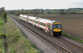
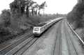
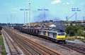
Photographic notes
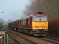
Only really good for trains travelling from Stenson to Sheet Stores. Best to stand on the flood bank and shoot between the trees.
General views - All photographs © Stuart Wood unless otherwise stated
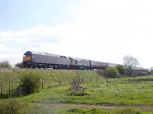
Fig 1 - Looking south
Disclaimer
All information contained within this is site is © Trainspots. The images used on this site remain the property of the original photographer, as credited at the top of the page, and are used with their kind permission.
The information on these pages is supplied for the benefit of railway enthusiasts who carry out a harmless hobby, and through the medium of photography and video, actually promote the railway industry. Railway enthusiasts can also act as eyes and ears against railway vandalism, and as such should surely be encouraged to do so by the supply of adequate information such as is found on this website.
This site has been created to assist railway photographers in their travels around the country. It is based on the personal knowledge and experience. No liability can be held against the web site or its contributions for incorrect information. Trainspots will endeavour to check all information and corrections will be accepted and posted accordingly.
Advice as to the locations general environment is given as a guide on each page. This information is a GUIDE only. ALWAYS be careful with your equipment, Trainspots can not be held responsible for your personal security. Avoid leaving your property on display for all to see, be aware of your surroundings at all times. There are, sadly, people who will not think twice about trying to steal your equipment.
Trainspots DOES NOT condone trespass and none of the information on this site should be taken as a right to trespass on either railway or private land. To the best of our knowledge all locations are publicly accessible areas, where they are not contact information will be given to the appropriate authority for permission to be obtained.
The content of this site is created and intended for all age ranges but the content of sites linked from this site are not subject to the same intentions. Trainspots will attempt to check links for validity but as time passes and the site grows this will not always be possible. Broken, or indeed updates to, links should be submitted to the editor for inclusion in the updates. All links external to the Trainspots site are opened in a new browser window. Trainspots has been running now for over 10 years and there are imitation sites and guides to railfotspots. But we are a free site and we continue on the path we started out on over a decade ago to provide a useful guide to UK Railway Photographic Locations.