New Mobile Site
We have just launched a new mobile version of this site - m.trainspots. This page will use your smart device's GPS to loctate you and guide you to locations that are close to your present location.
Location notes
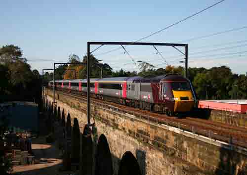
Slateford viaduct is located in the west of Edinburgh (just west of Slateford station and the junction for the Edinburgh freight suburban line) and is where the mainline from Edinburgh to Carlisle and Glasgow Central - either via Carstairs or Shotts - crosses the Water of Leith (as well as a builders yard and road).
Railway type and traffic
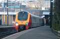
Throughout the day, Virgin Trains operate a roughly two hourly service in each direction between Edinburgh Waverley and Birmingham New Street, usually using Voyager units. In between these, First Trans-Pennine Express also operate services in each direction between Edinburgh Waverley and Manchester Airport using 185 units. East Coast also presently operate a roughly two hourly diagram in each direction to Glasgow Central from Edinburgh and beyond using class 91s and Mark 4 sets, although these services are rumoured to be stopping in the future. Arriva Cross Country also operate some early morning and late evening services to and from Glasgow Central using a mixture of Voyagers and HSTs. Extra Cross Country services to and from Glasgow Central are also rumoured in the future if East Coast stop running services to Glasgow. First ScotRail now operate a half hourly service in each direction throughout the day between Edinburgh Waverley and Glasgow Central via Shotts using either 156 and 158 DMUs. A small number of peak time Glasgow Central - North Berwick services also run through here using 322 EMUs.
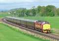
Finally on the passenger front, ScotRail's Caledonian Sleeper services to and from Edinburgh and the Highlands travel through here. Currently these services are booked for DB Schenker class 90s, although 67s and very very occasionally a 66 can also appear.
On the freight front, like many locations in and around Edinburgh, traffic is no longer as busy as it use to be. DBS still operate a regular weekday steel service between Teeside and Dalzell, sporadic coal services between Ayrshire and Cockenzie Power Station, a loaded car train from Tyne Yard to Mossend on a Wednesday and Friday morning and various light engine movements of mainly 66s and 67s between Millerhill and Mossend.
Freightliner Heavy Haul operate cement services between Oxwellmains and Viewpark usually 2 or 3 times per week and also infrequent cement services between Oxwellmains and Ayr Harbour using class 66/6s.
Finally, DRS operate regular flask services between Carlisle and Torness, usually hauled these days either by class 37s or class 66/4s either double heading or in top and tail mode.
Environment
The shots of trains on Slateford Viaduct come from the Union Canal tow path which also crosses the Water of Leith on an adjacent aqueduct . During the day, the tow path can be quite busy with people walking and cyclists, so you should try to be aware that you are not causing an obstruction - particularly if you are standing on the narrow part of the towpath on the aqueduct itself.
While it is an inner city location, there is no lighting on the canal towpath, so it is not really advisable to walk along here at night, particularly with expensive camera equitment. The location is also near the home ground of Heart of Midlothian, so football colours (particularly those of Scottish teams) should probably also be avoided just to be safe.
While it is an inner city location, there is no lighting on the canal towpath, so it is not really advisable to walk along here at night, particularly with expensive camera equitment. The location is also near the home ground of Heart of Midlothian, so football colours (particularly those of Scottish teams) should probably also be avoided just to be safe.
Road directions
Slateford is located on the main A70 that heads west from Edinburgh city centre. From the city centre follow signs for Gorgie/Haymarket when you reach Haymarket Junction take a left and follow this road all the way to the next junction near Gorgie, go straight across and up this road, at the top take a right and stay on this road until the next junction where you will see Slateford station above you on the left and Asda on the right. Continue straight through the lights and under the railway and you will see the canal bridge in front of you just before another set of traffic lights. From here, there is are two sets of steps up to the canal towpath and the viaduct either side of the lights.
From the west, the easiest way to reach Slateford from the A720 (Edinburgh City Bypass) is to take one of the turn offs for Wester Hailes and then follow the signs for the A70, Slateford and the Corn Exchange which is located behind Asda.
Click here to set up your location for directions to this location
Slateford Viaduct map co-ordinates
Parking
There are a few side streets in the vicinity which you can park your car in, although spaces can often be limited. The nearby 24 hour Asda does have a large car park, although again this can also get quite busy at times.
Public transport
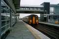
First ScotRail services between Edinburgh Waverley and Glasgow Central via Shotts call at Slateford station (just a few minutes walk from the viaduct) roughly hourly throughout the day. The latest timetable pdf can be found on the Scotrail website.
Lothian Buses services 4, 34, 35 and 44 also frequently pass Slateford station to and from the city centre, while First Bus also operate a number 44 service to and from the city centre. Details on Lothian Buses services can be found on the Lothian Buses website.
Click here to set up your location for directions to this location
Amenities
There is a 24 hour Asda at Slateford just a few minutes walk from the viaduct which also has toilets and a McDonalds cafe inside.
As the mainroad continues towards the city centre after Slateford station, there is also a BP garage on the right hand side which a Marks and Spencers shop.
Finally, just at the bottom of the steps between the viaduct and aquduct, there is the Water of Leith visitor centre which has a cafe which sells tea, coffee, hot chocolate and light refreshments.
Accommodation
While there is not anything in the immediate vicinity, there are lots of hotels and B&Bs in and around nearby Edinburgh city centre.
Sun Compass
Sun Compass using Suncalc by brought to you by Vladimir Agafonkin:
It might be necessary to adjust the time to suit your visit, this link should open with the current day.
Slateford Viaduct
Streetmap links
Slateford Viaduct general view map
Slateford Viaduct close up map
Windows Local Live Link - image quality may vary
Slateford Viaduct
It might be necessary to adjust the time to suit your visit, this link should open with the current day.
Slateford Viaduct
Googly map
Slateford Viaduct general view map
Slateford Viaduct close up map
Windows Local Live Link - image quality may vary
Slateford Viaduct
Who likes this location on facebook
Railway Gen Group
Photographic notes
The railway travels at a roughly North East - South West axis over the viaduct. As the adjacent aqueduct is on the south east side of the line, the sun is in a good position for photographs of trains heading towards Edinburgh from early morning (it is possible to photograph the inbound Edinburgh sleeper in the summer when it passes between 06:55 and 07:00) until mid to late morning (depending on the time of year) when the sun starts to move around and makes the angle more and more favourable for stuff heading away from Edinburgh. The going away from Edinburgh shot is on until about mid afternoon when the sun starts to move around to the other (unphotographical) side of the viaduct.
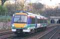
For the inbound shot, there are two vantage points. Firstly, there is a fairly head-on shot available from the steps that lead up to the canal towpath from the Water of Leith visitor centre and walkway. Alternatively, if you want a wider angle of the viaduct in your shot, you can take pictures from the towpath just before it goes onto the aquduct.
To take pictures of anything heading away from Edinburgh, you have to walk across and stand on the far end of the aqueduct - not recommended if you don't like heights! As mentioned earlier though, as the towpath is narrow on the aqueduct, be aware of cyclists and pedestrians trying to pass you.
Anyone wishing to take videos, it should be noted that as well as the nearby busy mainroad, there is a busy builders yard below both the viaduct and aqueduct which produces a lot of noise throughout the day.
General views - All photographs © Steven Brykajlo unless otherwise stated
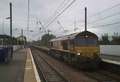
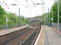
Fig 1 - Looking west
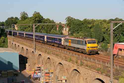
Fig 2 - Looking east
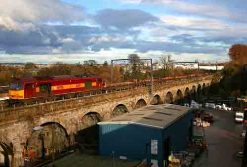
Fig 3 - Looking west
From the steps.
Disclaimer
All information contained within this is site is © Trainspots. The images used on this site remain the property of the original photographer, as credited at the top of the page, and are used with their kind permission.
The information on these pages is supplied for the benefit of railway enthusiasts who carry out a harmless hobby, and through the medium of photography and video, actually promote the railway industry. Railway enthusiasts can also act as eyes and ears against railway vandalism, and as such should surely be encouraged to do so by the supply of adequate information such as is found on this website.
This site has been created to assist railway photographers in their travels around the country. It is based on the personal knowledge and experience. No liability can be held against the web site or its contributions for incorrect information. Trainspots will endeavour to check all information and corrections will be accepted and posted accordingly.
Advice as to the locations general environment is given as a guide on each page. This information is a GUIDE only. ALWAYS be careful with your equipment, Trainspots can not be held responsible for your personal security. Avoid leaving your property on display for all to see, be aware of your surroundings at all times. There are, sadly, people who will not think twice about trying to steal your equipment.
Trainspots DOES NOT condone trespass and none of the information on this site should be taken as a right to trespass on either railway or private land. To the best of our knowledge all locations are publicly accessible areas, where they are not contact information will be given to the appropriate authority for permission to be obtained.
The content of this site is created and intended for all age ranges but the content of sites linked from this site are not subject to the same intentions. Trainspots will attempt to check links for validity but as time passes and the site grows this will not always be possible. Broken, or indeed updates to, links should be submitted to the editor for inclusion in the updates. All links external to the Trainspots site are opened in a new browser window. Trainspots has been running now for over 10 years and there are imitation sites and guides to railfotspots. But we are a free site and we continue on the path we started out on over a decade ago to provide a useful guide to UK Railway Photographic Locations.