New Mobile Site
We have just launched a new mobile version of this site - m.trainspots. This page will use your smart device's GPS to loctate you and guide you to locations that are close to your present location.
Location notes
The main station for the city of Dunfermline, this is located south east of the city centre, and is a 10-15 walk away. The station is located on the Fife Circle, and was originally called 'Dunfermline Lower'.
Dunfermline Upper, on the Oakley - Stirling route, closed, along with that line, in 1970, and is now the Carnegie Drive retail park.
During peak times Monday - Saturday, usually 07:00-10:00 and 16:00 - 18:00, there are inspectors in operation at the gates, so access to the platforms will be restricted unless travelling.
Railway type and traffic
The regular services are provided by First Scotrail, on Fife circle and Edinburgh - Cowdenbeath workings, using class 158 and 170 DMUs. There is a daily ECS working using a Virgin Voyager, which passes here at around 06:00 northbound, and 21:30 southbound. These times are approximate and can sometimes change.
Freight services are provided by DB Schenker, using class 66 locomotives hauling MGR trains. These will be heading to the Halbeath Shunting sidings, or Thornton DB Schenker depot if heading eastbound, and to Longannet, Ayrshire, or Millerhill if heading west/southbound.
The fife circle is also a diversionary route, if the ECML is closed between Inverkeithing and Kirkcaldy. If this happens, East Coast HSTs and other trains will pass through here non stop.
Environment
The station is south east of the city centre, and partly on an embankment, so it can get chilly. CCTV covers the station and it is fairly safe.
Road directions
From any direction, follow signs for the town centre. If you are coming from the south, you will pass the bus depot and Asdas, and see the rail bridge ahead. At the roundabout with the rail bridge, take the third exit onto Woodmill Street, and the station car park is the first on your left.
From the North, West or East, head for the town centre, and to the roundabout with the signposts for 'Townhill'. This is the roundabout where the police station is located. Once on there, take the dual carriageway road, and follow it down. The station is signposted on this road, and indeed on the roundabout.
Click here to set up your location for directions to this location
Dunfermline Town map co-ordinates
Parking
The station has two car parks. One is located on St. Margarets Drive, though it can only be entered from the southbound direction, as the road is a dual carriageway, while the other one is on Woodmill Street, adjacent to the southbound platform. Should either of these be full, carry on up St. Leonards Street, and park in Asdas car park, which you can do for three hours. All these car parks are free.
Public transport
Stagecoach in Fife, and these stop at the stops on St. Margarets Drive (7, 55, 76, 79) or Woodmill Street (D5 D6) In addition, services 19, D3, D4, D7, D8 all stop at the stops on St. Leonards Street, and Netherton Broad Street. These stops are about 5 minutes walk from the station.
Important:
In the evenings service 7 operates via New Row and Netherton Broad Street, not St. Margarets Drive. Service X54 does not stop at St Leonards Street or St Margarets drive. The nearest stop is the Bus station, which is a 10 minute walk away.
Click here to set up your location for directions to this location
Amenities
There is a kiosk and toilets in the booking hall, but these are only available when the station booking hall is open. Go to the National Rail website, go to station facilities then key in Dunfermline Town for full details.
In addition, there is a canopy on platform 2, and a shelter on platform 1. There is also a heated waiting room on platform 1, but again, only when the booking hall is open.
There is a chip shop on Netherton Broad Street, and Asda is further up St Leonards Street. Dunfermline city centre is a short bus ride, or 10-15 minute walk away.
Accommodation
There are a few places in Dunfermline, including Travelodge at Halbeath and you can get more accommodation info at Visit Scotland.com
Sun Compass
Sun Compass using Suncalc by brought to you by Vladimir Agafonkin:
It might be necessary to adjust the time to suit your visit, this link should open with the current day.
Dunfermline Town
Streetmap links
Dunfermline Town general view map
Dunfermline Town close up map
Windows Local Live Link - image quality may vary
Dunfermline Town
It might be necessary to adjust the time to suit your visit, this link should open with the current day.
Dunfermline Town
Googly map
Dunfermline Town general view map
Dunfermline Town close up map
Windows Local Live Link - image quality may vary
Dunfermline Town
Who likes this location on facebook
Railway Gen Group
Photographic notes
The station sits on a bend, so you do not get too long a view ahead, either way. The station is signalled for bi-directional running, but this very rarely happens.
There is traffic noise from nearby, but you can still get some videos. Please bear in mind, as well, that the station is partly on an embankment, and the wind can also affect the noise on a video.
When there are inspectors at the gates, and you do not have a ticket to travel, there are two other photo opportunites available. The first one is to go out of the station on platform 2 (i.e. the Cardenden platform) and head over past the cycle lockers to an opening into the park area. As you enter it, you will notice a path going to the right, which runs next to a wire fence, paralell with the tracks. Follow this path up and you will then come to a T junction, with a bridge on your right. Stand on the bridge, and an alternative shot is available of the station.
Also, by leaving the Cardenden platform, turn left, and head along the station building. At the end, where the road goes up a hill to the t-junction on St. Margarets Drive, turn left, away from the road, and head along the wall with the spiked railings on it. A clear shot looking west/south west can be obtained. This footpath carries onto the pedestrian bridge over the road, where more shots are obtainable.
General views - All photographs © Robert Clarke unless otherwise stated
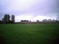
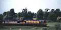
Fig 1 - Looking west
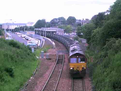
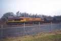
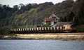
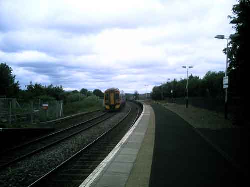
Fig 2 - Looking east
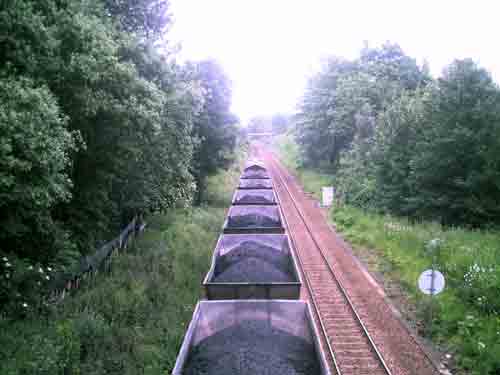
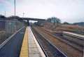
Fig 3 - Looking east
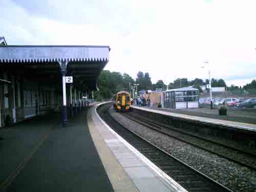
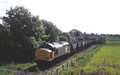
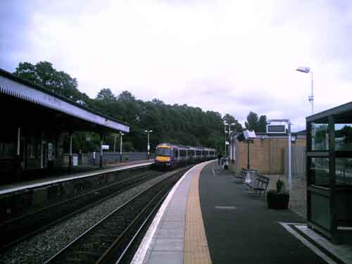
Fig 4 - Looking west
Just out of sight is the junction that takes trains onto the Longannet branch. There is a reminder sign at the end of the platform warning drivers of the number of the signal.
Fig 5 - Looking west
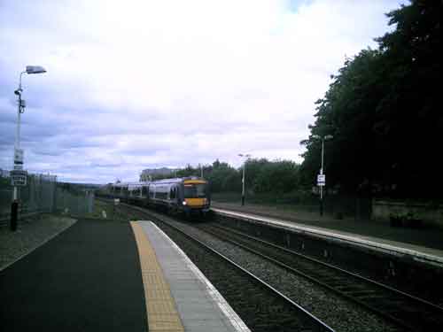
Fig 6 - Looking east
Disclaimer
All information contained within this is site is © Trainspots. The images used on this site remain the property of the original photographer, as credited at the top of the page, and are used with their kind permission.
The information on these pages is supplied for the benefit of railway enthusiasts who carry out a harmless hobby, and through the medium of photography and video, actually promote the railway industry. Railway enthusiasts can also act as eyes and ears against railway vandalism, and as such should surely be encouraged to do so by the supply of adequate information such as is found on this website.
This site has been created to assist railway photographers in their travels around the country. It is based on the personal knowledge and experience. No liability can be held against the web site or its contributions for incorrect information. Trainspots will endeavour to check all information and corrections will be accepted and posted accordingly.
Advice as to the locations general environment is given as a guide on each page. This information is a GUIDE only. ALWAYS be careful with your equipment, Trainspots can not be held responsible for your personal security. Avoid leaving your property on display for all to see, be aware of your surroundings at all times. There are, sadly, people who will not think twice about trying to steal your equipment.
Trainspots DOES NOT condone trespass and none of the information on this site should be taken as a right to trespass on either railway or private land. To the best of our knowledge all locations are publicly accessible areas, where they are not contact information will be given to the appropriate authority for permission to be obtained.
The content of this site is created and intended for all age ranges but the content of sites linked from this site are not subject to the same intentions. Trainspots will attempt to check links for validity but as time passes and the site grows this will not always be possible. Broken, or indeed updates to, links should be submitted to the editor for inclusion in the updates. All links external to the Trainspots site are opened in a new browser window. Trainspots has been running now for over 10 years and there are imitation sites and guides to railfotspots. But we are a free site and we continue on the path we started out on over a decade ago to provide a useful guide to UK Railway Photographic Locations.