New Mobile Site
We have just launched a new mobile version of this site - m.trainspots. This page will use your smart device's GPS to loctate you and guide you to locations that are close to your present location.
Location notes
Greenhill Lower Junction is in Central Scotland, about 5 miles west of Falkirk. There are two junctions, with the higher junction where the Glasgow to Falkirk High and Glasgow to Falkirk Grahmston/Stirling routes split, and the lower junction where the Cumbernauld to Falkirk Grahmston/Stirling and Glasgow to Falkirk Grahmston/Stirling meet.
Railway type and traffic
LOWER LINES
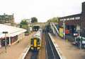
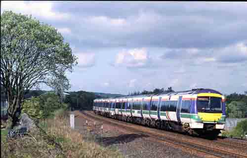
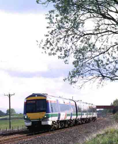
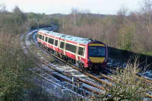
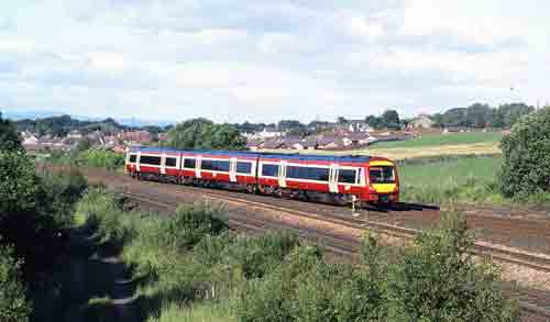
Scotrail services from Falkirk Grahamston, Dunblane, Stirling and Aberdeen to Glasgow Queen Street, including SPT liveried 156s and the two 170s.
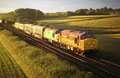
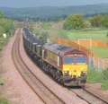
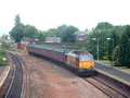
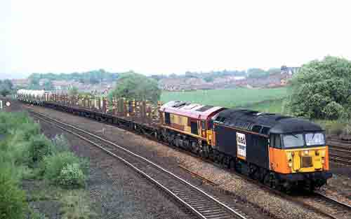
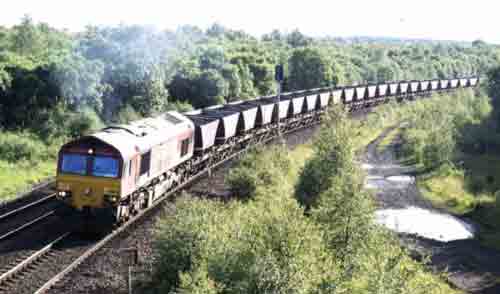
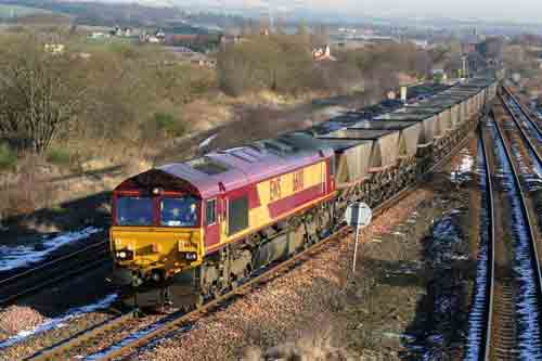
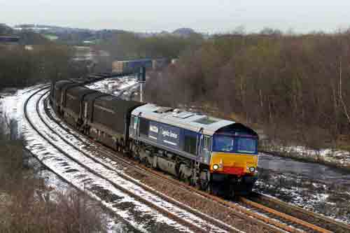
DB Schenker coal and balancing empties. DB Schenker services from Mossend to Grangemouth, Aberdeen and Inverness. DB Schenker parcels vans to and from Aberdeen and Inverness. DRS services between Grangemouth and Daventry.
HIGH LINES
Scotrail Edinburgh Waverley to Glasgow Queen Street services.
Scotrail services from Falkirk Grahamston, Dunblane, Stirling and Aberdeen to Glasgow Queen Street, including SPT liveried 156s and the two 170s.
DB Schenker coal and balancing empties. DB Schenker services from Mossend to Grangemouth, Aberdeen and Inverness. DB Schenker parcels vans to and from Aberdeen and Inverness. DRS services between Grangemouth and Daventry.
HIGH LINES
Scotrail Edinburgh Waverley to Glasgow Queen Street services.
Link to Real Time Trains
RTT Link Greenhill Lower Junction
This link should be close to the location, but may not be the actual location so please check the page. This link will take you to what is happening 'around now'. Dates and times can be changed at the top of the page.
This link should be close to the location, but may not be the actual location so please check the page. This link will take you to what is happening 'around now'. Dates and times can be changed at the top of the page.
Environment
On the edge of a new housing, but estate otherwise rural.
Road directions
FROM THE EAST
Leave the M876 at junction 1 westbound and continue to the end of the slip road. BEWARE TWO WAY TRAFFIC USES THIS ROAD SHORTLY AFTER LEAVING THE MOTORWAY. At the T junction turn right and cross the River Carron. At the roundabout take the second exit.
FROM THE WEST
Leave the M876 at junction 1 eastbound and continue to the end of the slip road. Turn left and go under the motorway. At the roundabout take the third exit.
FROM BOTH DIRECTIONS
Follow this road until it forks, take the left fork as the right fork leads back onto the motorway! Continue along this road and take the fourth turning on the left, this road descends a short hill and turns ninety degrees to the right at the bottom of the hill, continue with a sunken park on your left hand side until you reach the T junction. Turn left at the T junction and continue until you reach a mini roundabout, take the second exit, Bridge Street, sign posted 'High Bonnybridge and Industry' continuing over the canal and straight on passing St. Josephs School on your right. Pass under the railway bridge then turn immediately right into Reilly Road, continue along this road with the railway running alongside on your right. When you come to the T junction park your car at the foot of the approach to the bridge.
Click here to set up your location for directions to this location
Greenhill Lower Junction map co-ordinates
Parking
See road directions.
Public transport
An hourly bus service (X37) from Falkirk to Glasgow stops at the end of Reilly Road. This can be boarded at Falkirk bus station or opposite the Mariner Centre near to Camelon railway station.
Click here to set up your location for directions to this location
Click here to set up your location for directions to this location
Amenities
Bonnybridge hosts pubs and shops including a fish and chip shop.
Sun Compass
Sun Compass using Suncalc by brought to you by Vladimir Agafonkin:
It might be necessary to adjust the time to suit your visit, this link should open with the current day.
Greenhill Lower Junction
Streetmap links
Greenhill Lower Junction general view map
Greenhill Lower Junction close up map
Windows Local Live Link - image quality may vary
Greenhill Lower Junction
It might be necessary to adjust the time to suit your visit, this link should open with the current day.
Greenhill Lower Junction
Googly map
Greenhill Lower Junction general view map
Greenhill Lower Junction close up map
Windows Local Live Link - image quality may vary
Greenhill Lower Junction
Who likes this location on facebook
Railway Gen Group
Photographic notes
The road bridge crosses the lower lines to Cumbernauld and Glasgow Queen Street. To photograph the high lines you need to go under the nearby under bridge and turn left onto the playing fields.
The sun is best for trains from the west in the morning and from the east in the afternoon. After about 18:00 (in the spring and summer) the sun has gone around and is best from the far side of the bridge.
Rail-net GWRB Tour 2004 - Checking the lineThe sun is best for trains from the west in the morning and from the east in the afternoon. After about 18:00 (in the spring and summer) the sun has gone around and is best from the far side of the bridge.
Ewan's Railway Photos - Greenhill
General views - All photographs © Peter Kellett unless otherwise stated
Fig 1 - Looking west
The high level line.
Fig 2 - Looking east
The high level line.
Fig 3 - Looking south east
The Cumbernauld line.
Fig 4 - Looking south west
The Cumbernauld line.
Fig 5 - Looking north east
The Cumbernauld line.
Fig 6 - Looking north west
The Cumbernauld line.
Fig 7 - Looking north west
The low level to high level connecting line.
Fig 8 - Looking south east
The low level to high level connecting line.
Disclaimer
All information contained within this is site is © Trainspots. The images used on this site remain the property of the original photographer, as credited at the top of the page, and are used with their kind permission.
The information on these pages is supplied for the benefit of railway enthusiasts who carry out a harmless hobby, and through the medium of photography and video, actually promote the railway industry. Railway enthusiasts can also act as eyes and ears against railway vandalism, and as such should surely be encouraged to do so by the supply of adequate information such as is found on this website.
This site has been created to assist railway photographers in their travels around the country. It is based on the personal knowledge and experience. No liability can be held against the web site or its contributions for incorrect information. Trainspots will endeavour to check all information and corrections will be accepted and posted accordingly.
Advice as to the locations general environment is given as a guide on each page. This information is a GUIDE only. ALWAYS be careful with your equipment, Trainspots can not be held responsible for your personal security. Avoid leaving your property on display for all to see, be aware of your surroundings at all times. There are, sadly, people who will not think twice about trying to steal your equipment.
Trainspots DOES NOT condone trespass and none of the information on this site should be taken as a right to trespass on either railway or private land. To the best of our knowledge all locations are publicly accessible areas, where they are not contact information will be given to the appropriate authority for permission to be obtained.
The content of this site is created and intended for all age ranges but the content of sites linked from this site are not subject to the same intentions. Trainspots will attempt to check links for validity but as time passes and the site grows this will not always be possible. Broken, or indeed updates to, links should be submitted to the editor for inclusion in the updates. All links external to the Trainspots site are opened in a new browser window. Trainspots has been running now for over 10 years and there are imitation sites and guides to railfotspots. But we are a free site and we continue on the path we started out on over a decade ago to provide a useful guide to UK Railway Photographic Locations.